An online project under the direction of the CAPE ANN MUSEUM
Catalog entry
inv. 171
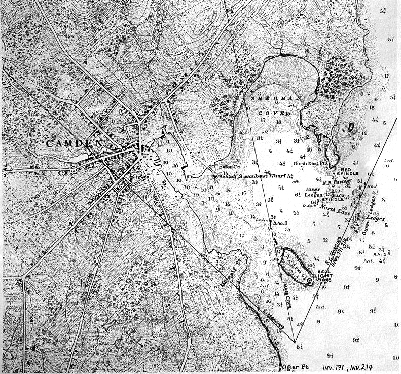
Camden Mountains from the South Entrance to Harbor
1855 Graphite on paper (2 sheets) 10 1/2 x 26 in. (26.7 x 66 cm) Inscribed: lower left (in pencil): Camden Mts. from the South Entrance to Harbor / F.H. Lane del. / Sept. 1855 Lane-Hooper-Stevens; Inscribed lower center (in pencil): 2 pcs.; inscribed lower right (in pencil): sketch taken from the boat on our return / to Rockland
|
Supplementary Images
Explore catalog entries by keywords view all keywords »
Historical Materials
Below is historical information related to the Lane work above. To see complete information on a subject on the Historical Materials page, click on the subject name (in bold and underlined).
The Camden Mountains, also called the Camden Hills, are located just northeast of the town of Camden. The range includes Mount Megunticook, upon whose shoulders Mount Battie sits, Cameron Mountain, and Bald Rock Mountain. They stand high above West Penobscot Bay between Camden and Lincolnville, looking east toward Mount Desert and the rising sun. The Wabenaki, loosely defined as the "people of the dawn," greeted their maritime world, "the dawn land," from the Camden Hills, and other high points, including Mount Wallamatogus in Penobscot (460 feet), Awan-adjo (at Bluehill), Caterpillar Hill in Sedgwick (with its panoramic sweep which stretches from the Camden Hills to Mount Desert and far out into Penobscot Bay), and atop Cadillac Mountain, Mount Desert. It is from the same peaks that artists and pilgrims alike still climb to view Penobscot Bay.
Mad-kam-ig-os'-sek, "big high land," is the Wabenaki word for Camden, and Meg-un-ti-cook, "big mountain harbor," the name for the harbor, is now used for Mount Megunticook. The inner harbor, quiet and safe, would have been the ideal place for a large, oceangoing canoe to lay up when the sea was rough. Capt. John Smith visited this place in 1614, during the Beaver Wars, and noted that the high mountains were used as a refuge from the Mik'maq of the Maritimes who fought the Wabenaki of Penobscot Bay to maintain their place as middlemen in the fur trade. These raiders would travel along the Downeast coast in their shallops. Mount Battie, of many spellings, was noted as Mount Betty in documents dating from 1757. It is a European corruption of a word borrowed from another place, the Madambettox Hills of Rockland.
-Mark Honey
References:
Eckstorm, Fannie Hardy, "Indian Place-Names of the Penobscot Valley and the Maine Coast," University of Maine Studies, 2nd Series, #55, November 1941, reprinted 1960 by the University of Maine Press. DeLorme's Atlas. Frank G Speck's "Penobscot Man," University Of Pennsylvania Press, 1940.
Newsprint
Gloucester Telegraph
"The Reef of Norman's Woe ... is now commemorated in painting too, one of the finest pictures from Lane's easel. ... The sketch was made at the pretty spot commonly called, we believe, Master Moore's Cove. Being some little way off the main track to Rafe's Chasm, it is seldom visited, except by the more inquisitive lovers of nature who leave the beaten road to pry out such pleasant places. ... We wish it might find a home buyer, rather than go off to enrich another community." Flowery description follows, then "There is another and larger work in the artist's studio, which, happily, is to be retained. It received much well deserved notice and commendation. The subject is a view southward from the 'Cut,' with the picturesque promontory commonly known as 'Stage Fort,' and historically interesting as the supposed spot of the 'Landing at Cape Ann' in the middle distance, and Eastern Point on the extreme left." More description follows, "Among other attractions of the studio, and particularly worthy of mention, is a cabinet picture with an effect similar to the Norman's Woe. The subject is chosen from the many sketches of the grand scenery of the Maine sea-coast with which the artist's portfolio is rich. It is a view of the Camden mountains sketches from the Graves, a jagged ledge far out in the bay, which is accessible in only the smoothest water."
Also filed under: Cut, The (Stacy Blvd.) » // Newspaper / Journal Articles » // The Graves »
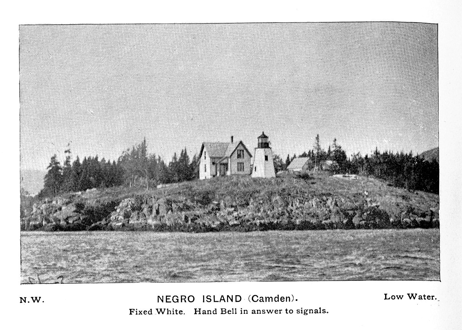
Curtis Island is located a short distance from Camden Harbor in Penobscot Bay. The island was known as Negro Island, from Revolutionary times to the 1930s, and in the early part of the nineteenth century as Mark Island. Abraham Ogier, in a deposition submitted in 1832, claimed that he had pastured hogs on the island and planted potatoes as early as 1773, and that he was driven off by the British in 1779. His grandson Lewis pastured sheep here for 40 years. The island was sold to the US government for a light station for $400 in 1835, and the Negro Island Light was established by an appropriation of $4500 in 1836. M.K.M. Bowers was the light keeper when Lane portrayed the island at dawn. The island was renamed Curtis Island in 1934 after Cyrus H.K. Curtis, publisher of the "Saturday Evening Post," a longtime summer resident and benefactor of Camden.
– Mark Honey
Reference:
McLane, Charles B, and McLane, Carol Evarts, "Islands of the Mid-Maine Coast," Penobscot Bay, Volume 1, Revised Edition, Tilbury House, Publishers, Gardiner, Maine, and the Island Institute, Rockland, Maine, page 124.
Photograph
From book "The Illustrated Coast Pilot with Sailing Directions. The Coast of New England from New York to Eastport, Maine including Bays and Harbors." Published by N.L. Stebbins, Boston, Mass. 1891
Also filed under: Camden, Maine – Negro (Curtis) Island Light »
Photograph
National Archives
Also filed under: Camden, Maine – Negro (Curtis) Island Light »
The Curtis Island Light is located on the seven-acre Curtis Island, a short distance off the coastline of Camden, Maine in the Penobscot Bay. The island was formerly known as Negro Island because the African-American cook of early settler, James Richards, admired the island greatly, but was later named Curtis Island in memory of Camden summertime resident, Cyrus H. K. Curtis. The original lighthouse was built in 1835 by contractor George Gault. Fifteen years later, an inspection report from 1850 stated that the lighthouse needed "immediate attention" and in 1855 the lighthouse was given a wooden outer sheath and new shingling in an attempt to stop the leaks. Lane painted the Curtis Island Light on at least two separate occasions, in 1852 and 1855, during his trips to the Maine coast.
This is information has been shared with the Lane project by Jeremy D'Entremont. More information can be found on his website, www.newenglandlighthouses.net and in his book The Lighthouse Handbook of New England.
Photograph
From book "The Illustrated Coast Pilot with Sailing Directions. The Coast of New England from New York to Eastport, Maine including Bays and Harbors." Published by N.L. Stebbins, Boston, Mass. 1891
Also filed under: Negro (Curtis) Island, Camden Harbor »
Photograph
National Archives
Also filed under: Negro (Curtis) Island, Camden Harbor »
Joseph Story Hooper accompanied Lane and Stevens on their 1855 boating expedition in Maine. He traveled as an assistant and companion with Lane from Gloucester to Rockland, Maine, where Stevens met them with a boat. According to an inscription on Bear Island from Western Side of N. East Harbour, 1855 (inv. 136) a painting was made from that drawing, and presented to Hooper, who by then had moved to Dubuque, Iowa. In 1855, Hooper had recently moved to Gloucester, Massachusetts from Manchester, Mass, Massachusetts with his wife, Julia Ann Foster, who was the sister of Florence Foster, and a cousin of Stevens's wife, Caroline Foster. (1)
Hooper was born in 1827 in Manchester, Massachusetts. His parents were Joseph Hooper, Jr. (1786–1860) and Lucy Story Hooper (who died in 1827 shortly after the birth of Joseph Story Hooper, her sixth child).
At the time of his marriage to Julia Ann Foster in 1849 (in Manchester), Joseph S. Story was a “cabinet maker.” Julia Ann Foster (Gloucester, 1828–1912) was a daughter of Capt. Thomas Jefferson Foster (1801–65) and Julia Ann Babson Foster. Other children in the family were: Elizabeth (b. 1837, never married), Mary Eliza (b. 1830, never married) and Florence (b. 1839, never married).
Joseph S. Hooper and Julia Ann Foster moved to Dubuque, Iowa sometime between 1856 and 1860; the 1860 Federal Census shows Joseph in Dubuque working as a “merchant.” In the 1870 Census, he was described as a “furniture maker.” Together, Joseph and Julia had six children, born between 1852 and 1865 (including twins).
Julia Ann Foster Hooper outlived her husband by some thirty-five years. They are both buried in Dubuque.
– Martha Oaks
(1) Sarah Dunlap and Stephanie Buck, Fitz Henry Lane: Family and Friends. (Gloucester, MA: Church & Mason Publishing; in association with the Cape Ann Historical Museum, 2007), 118.
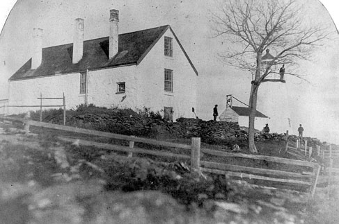
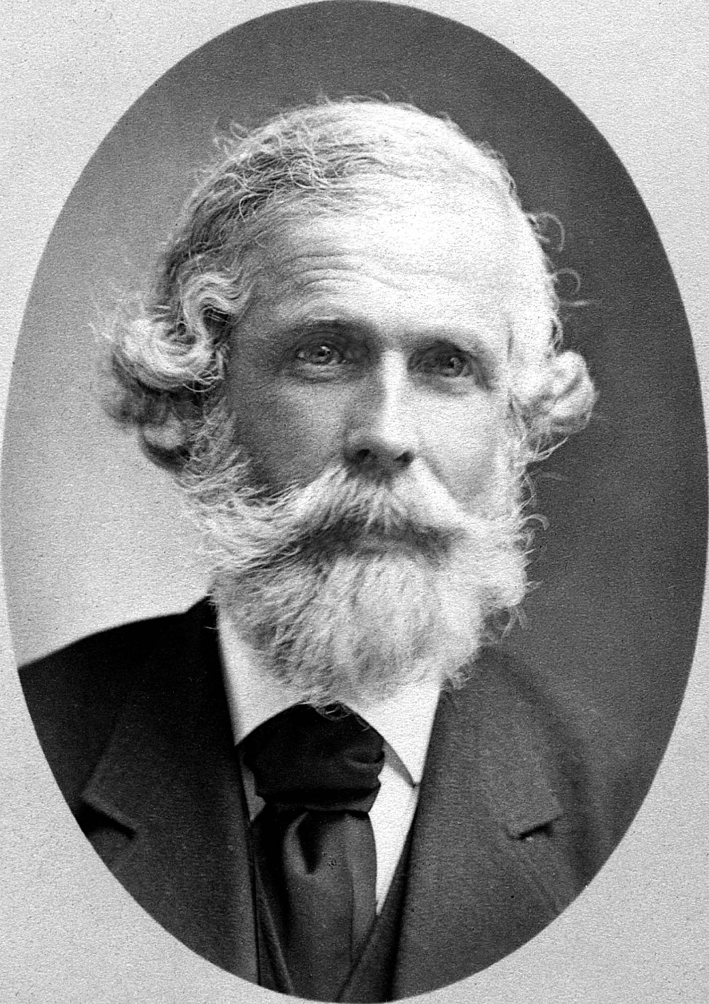
Joseph Lowe Stevens, Jr. (1823–1908) was Lane's closest friend and traveling companion. He was also executor of Lane's estate, and a tireless promoter of Lane's work. He was a supporter of abolition and animal welfare, and an active member of the Gloucester Lyceum. It was the Stevens family who encouraged Lane to make a print of Castine and who published and promoted it there Castine, from Hospital Island, 1855 (inv. 448). Joseph first worked as a dry goods salesman and in later life “engaged in the wholesale dry-goods and woollen trade on Summer St. Boston, travelling daily to and fro” on the train. (1)
Joseph's father, Dr. Joseph Lowe Stevens, Sr., was born in Andover, Massachusetts, and raised in Gloucester, Massachusetts. He married Dorothy Little of Castine, Maine, where the couple settled, and where Joseph Jr. was born in 1823. In the spring of 1840, at the age of seventeen, Joseph, Jr. left Maine and moved to Gloucester to work in his uncle’s Samuel Stevens' dry goods store and to live with his grandfather, Zachariah Stevens. Seven years later, Joseph, Jr. married his second cousin, Caroline Stevens Foster. The couple eventually had five children, one of whom died very young.
Like most of the educated population of the town, Joseph joined the Gloucester Lyceum shortly after arriving in town; the signature of John J. Piper appears next in the membership book; and the next after him was Fitz Henry Lane. (2) Joseph remained involved with the Gloucester Lyceum and Library for most of his life, acting as director for many years, and was the superintendent at the time it became incorporated as the Gloucester Lyceum and Sawyer Free Library.
Joseph also helped his father work on a history of Castine, and he was sufficiently concerned about the welfare of animals to serve on the boards of three animal-aid societies. He became the secretary of the Society for the Prevention of Cruelty to Animals and the New England Humane Education Society, and treasurer of the Band of Mercy. (3) Joseph was committed to more than animal welfare; he involved himself in the Free Soil movement and the slavery debate, to the extent that he left Gloucester for Kansas in 1855 “to see for himself what was going on,” returning about two years later. (4)
Joseph L. Stevens, Jr. first became friends with Lane after the artist had returned from Boston and had set up a studio on Elm Stree. That same year, Joseph invited Lane to accompany him to Castine. It was the first of many such trips to the Maine coast, where Lane sketched and painted and visited with Joseph’s parents.
When Lane fell out with his brother-in-law, Joseph Stevens came to the rescue by purchasing the contested stone house from Lane and evicting the troublesome in-laws. He was also at Lane’s side when he died and was named as one of two executors in Lane’s will. In addition, he inherited two-thirds of the residual property of the estate.
Joseph’s wife Caroline died in 1886, and Joseph left Gloucester nine years later to marry Charlotte M. Todd of Milton. He remained there until his own death. He is buried in Oak Grove cemetery alongside Caroline and their infant son. Lane is also buried in their family plot.
– Stephanie Buck
(1) Joseph L. Stevens Jr., letter written as Superintendent of the Sawyer Free Library, for the 1876 Women’s Time Capsule. Gloucester Archives, CC195 and AS300.
(2) Gloucester Lyceum Records, vol. 1, 1830–1852.
(3) The New England Humane Education Society is not to be confused with the coastal lifesaving institution which was then known as the Massachusetts Humane Society. The Band of Mercy was associated with the Massachusetts SPCA.
(4) F. A. Sharf, "Fitz Hugh Lane: Visits to the Maine Coast, 1848–1855," Essex Institute Historical Collection 98, no. 2 (April 1962): 112.
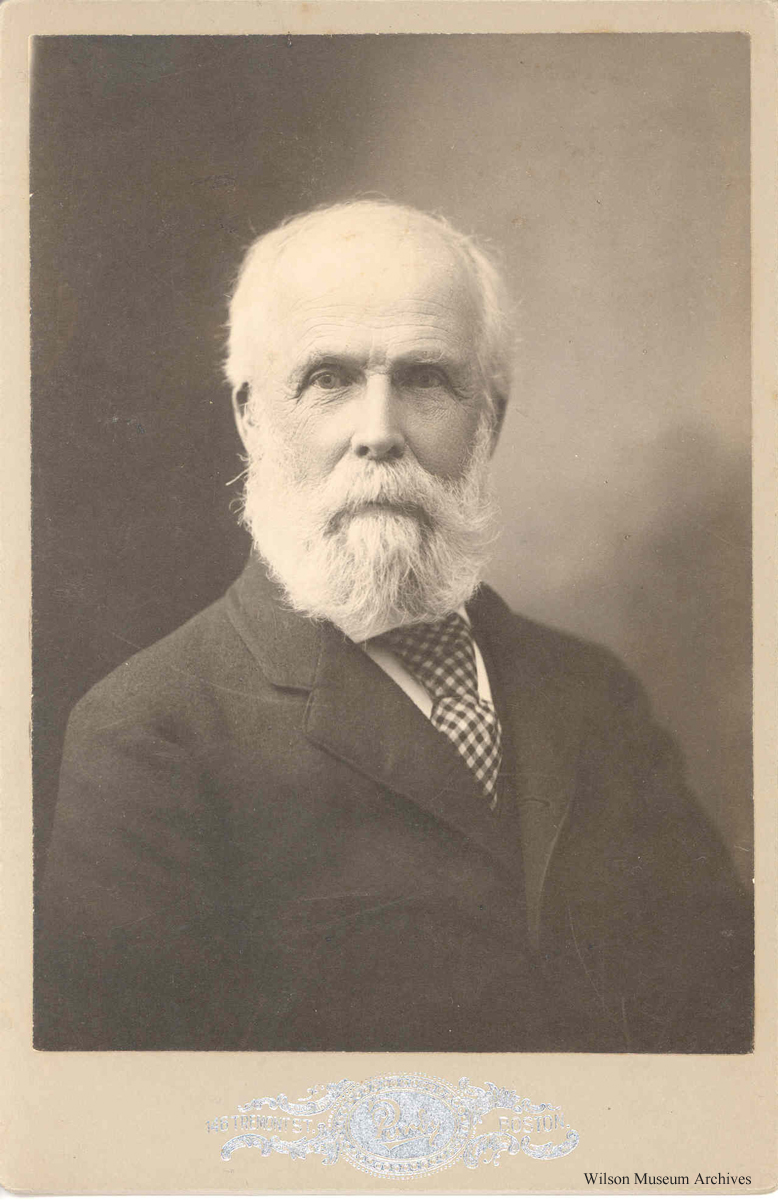
Photograph
Wilson Museum, Castine, Maine (a02156)
Also filed under: Historic Photographs »
Newsprint
Gloucester Daily Telegraph
Article by Joseph L. Stevens
"The beauties of this place [Maine] are well known and appreciated among artists. We heard of Bonfield and Williams who had reluctantly left but a short time before. Fishe had spent several weeks there. Champney and Kensett were then in another part of the island, and we have reason to believe that Church and some others were in the immediate vicinity–Lane who was with us, made good additions to his portfolio."
Personal journal
Wilson Museum, Castine, Maine
Box 2, F1 (A00772)
John Stevens was the younger brother of Joseph Stevens, and acquainted with Lane, spending time with him in Gloucester and at the family home in Castine. His journal, quoted below, includes reference to hunting plover and teal, school, sailing, local events. Mentions Castine mill, lighthouse, and block house.
"Friday [September] 17th: Cloudy all day. Wind N. blowing quite hard. A British Rig loaded with salt from Liverpool came into port last night. She run way up by the Monument and got aground. They kedged her off this P.M. and came down. She came in with one of these old English charts as her guide. They have the town set down on the Brooksville side, two miles + three quarters from the lighthouse."
"Wednesday [September] 22. . .Went down to the Indians Camp on the Back Cove. There were five camps of them."
Visits Gloucester from Castine:
"Wednesday [October] 27th. . .Left for Gloucester [from Boston] at 5 o'clock this P.M. arrived there safe + sound at 6 1/2 o'clock; went right down to the store and saw Joe. We then went up to his house and got supper.
"Thursday [October] 28th. At. Gloucester. Pleasant day. Went down to the "Cut" a gunning this morning before breakfast but saw no birds. Went out in the harbor this forenoon alone, had a fine sail but couldn't get a chance at any birds. Went out again this P.M. got down to East Point Light and the wind died all away, so I had to scull home."
"Friday 29th. Very pleasant day, went out in the harbor this morning with Joe. Took a walk this A.M. with "Lina", called on Mr. Lane + Doct. Hildreth. Joe + I went out in the harbor this P.M. I fired at some birds several times, but didn't get any. . . ."
Also filed under: Biographical information » // Bird Hunting » // Castine » // Castine – School » // Chronology » // Cut, The (Stacy Blvd.) » // Diaries / Ledgers / Etc. »
Newspaper
Gloucester Telegraph
"Ignatius Winter v. Joseph L. Stevens, Jr.—This was an action of tort brought by the plaintiff to recover damages for personal injury in ejecting him from his dwelling house, as the plaintiff claimed. Defendant justified his expulsion of the plaintiff on the ground that he expelled him from his own, the defendant's house, using no more force than was reasonably necessary to accomplish this."
Also filed under: Newspaper / Journal Articles » // Winter, Ignatius »

Samuel Sawyer Papers
Cape Ann Museum Library & Archives
Archive Collection
"Met Mr. Tuckerman the artist walking with Jos. Stevens."
Also filed under: Diaries / Ledgers / Etc. » // Sawyer, Samuel » // Tuckerman, Stephen Salisbury »
Newspaper
Letter to the editor: "Fitz H. Lane's will and gift of the Old Fort painting in the Town Hall, sketched in 1859, from T. Sewell Lancaster and Joseph L. Stevens, executors."
Reply from Selectmen: "Mr. Lane was much esteemed by his townsmen not only for his skill as an artist, but also for his character, as a gentleman of Honor and Integrity."
Also filed under: Biographical information » // Funeral & Burial » // Lancaster, T. Sewall » // Newspaper / Journal Articles »
Handwritten list
Wilson Museum, Castine, Maine (A00787-1a-1d)
Also filed under: Castine » // Castine – Witherle & Co.'s Store » // Lithography (Sales & Exhibitions) » // Noyes, Samuel » // Publications » // Witherle, William Howe »
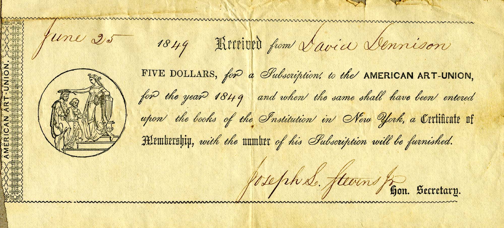
Printed paper receipt with handwritten entries by Joseph L. Stevens, Jr.
Cape Ann Museum, Gloucester, Mass.
Also filed under: New York – American Art Union »

Letter regarding the burning of the packet ship "Boston"
Cape Ann Museum, Gloucester, Mass.
"Dear Sir, Agreeable to your request that I would write something to attach to the picture in your possession of the Burning of the Packet Ship Boston in 1830, your object I suppose more fully to establish the fact that it is really one of the early productions of our fellow townsman and afterward most distinguished artist Fitz H. Lane.
The picture was drawn the same year by Mr. Lane from a sketch I made soon after the disaster aided by one of the passengers S.S. Osgood Esq. afterward a distinguished portrait painter. Mr. Lane had made not reputation of course at this time as an artist. And probably had received no instruction. It afforded me great pleasure to present this picture to you who was so devoted to him, knowing full well tho nothing very great of itself would be highly appreciative [...] as the early work of that [...] particular friend."
Also filed under: "Boston" (Packet Ship) » // Knight, Elias Davis » // Letters »
Letter
Cape Ann Museum Library & Archive, Gloucester, Mass.
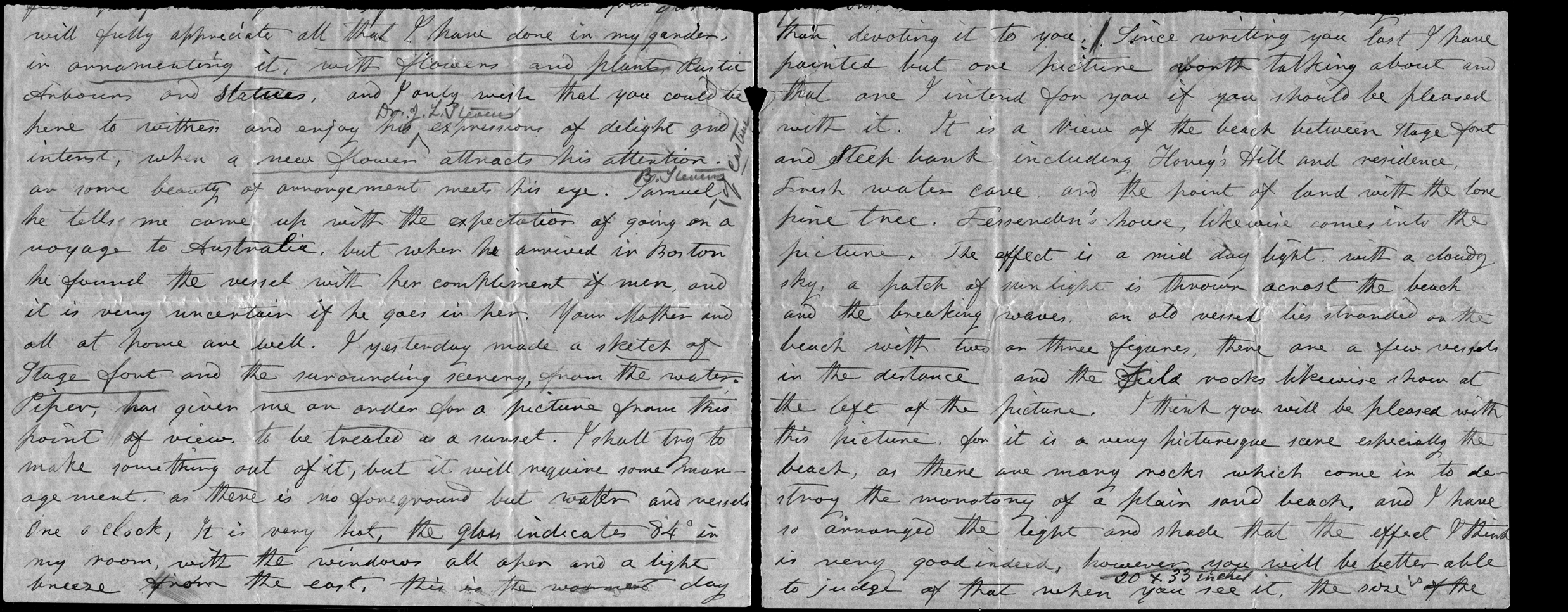
". . . will fully appreciate all that I have done in my garden, in ornamenting it, with flowers and plants, Rustic Arbours and Statues, and I only wish that you could be here to witness and enjoy his [Dr. J. L. Stevens] expressions of delight and interest, when a new flower attracts his attention, or some beauty of arrangement meets his eye. Samuel [B. Stevens of Castine] he tells me came up with the expectation of going on a voyage to Australia, but when he arrived in Boston he found the vessel with her compliment of men, and it is very uncertain if he goes in her. Your Mother and all at home are well. I yesterday made a sketch of Stage Fort and the surrounding scenery, from the water. Piper has given me an order for a picture from this point of view, to be treated as a sunset. I shall try to make something out of it, but it will require some management, as there is no foreground but water and vessels. One o’clock, it is very hot, the glass indicates 84° in my room, with the windows all open and a light breeze from the east, this is the warmest day . . .
. . . than devoting it to you. Since writing you last I have painted but one picture worth talking about and that one I intend for you if you should be pleased with it. It is a View of the beach between Stage Fort and Steep bank including Hovey’s Hill and residence, Fresh water cove and the point of land with the lone pine tree. Fessenden’s house, likewise comes into the picture. The effect is a mid day light with a cloudy sky, a patch of sunlight is thrown across the beach and the breaking waves, an old vessel lies stranded on the beach with two or three figures, there are a few vessels in the distance and the Field rocks likewise show at the left of the picture. I think you will be pleased with this picture, for it is a very picturesque scene especially the beach, as there are many rocks which come in to destroy the monotony of a plain sand beach, and I have so arranged the light and shade that the effect I think is very good indeed, however you will be better able to judge of that when you see it, the size is 20 x 33. . ."
Letter
Castine Historical Society, Maine
"[John] says Charles proposes to come down on Saturday—to return on Monday—so that may be so—I think of defering sending the pictures till then—it has been my intention to have sent them tomorrow. [??] went away on Monday last before I had time to have them boxed. Mr. Noyes will see to that. The have been, for a day or two, in Witherle & Co.'s store, where they were much admired—& a little remarkable, among the visitors there yesterday was Mr. King—the son of the Keeper of the Light—who was engaged in catching herring while you was at the Rock. He was very much pleased—thought it as natural as life—as it was to his recollection—having only left there a week since. He observed that he would not have believed Mr. Lane had so much in him. In case Charles does not come on Saturday how shall I direct the box—for I shall send it by express to Boston—I don't remember any thing was said about that. I hope you will come over to Owl's Head, as proposed—if so, you & Lane must come & spend one night at least. Our two teacher boarders came in the boat that took you away—but we can continue to accommodate some way or other. Mary is to leave on Monday next."
Four-page letter
Collection of the Cape Ann Museum Library & Archive, Gloucester, Mass.
"[The painting] is offered you for $150 on as long time and in as many notes at 3% interest as you choose. . . I believe this to be the only important painting of Gloucester Harbor that Lane never duplicated. . . .Returning from a Gloucester visit while I was still under the roof there, father brought a print of Lane's first Gloucester view, bought of the artist at his Tremont Temple studio in Boston. An extra dollar had been paid for coloring it. For a few years it was a home delight.. . .I had been a few years in Gloucester when Lane began to come, for part of the time a while, if I remember rightly. He painted in his brother's house, "up in town" it then was. I recall visits there to see his pictures. But it was long after, that I could claim more than a simple speaking acquaintance. The Stacys were very kind, aiding him as time went on in selling paintings by lot. I invested in a view of Gloucester from Rocky Neck, thus put on sale at the old reading room, irreverently called "Wisdom Hall." And they bought direct of him to some extent, before other residents. Lane was much my senior and yet we gradually drifted together. Our earliest approach to friendship was after his abode began in Elm Street as an occupant of the old Prentiss [sic-corrected Stacy] house, moved there from Pleasant. I was a frequenter of this studio to a considerable extent, yet little compared with my intimacy at the next and last in the new stone house on the hill. Lane's art books and magazines were always at my service and a great inspiration and delight—notably the London Art Journal to which he long subscribed. I have here a little story to tell you. A Castine man came to Gloucester on business that brought the passing of $60 through my hands at 2 1/2 % commission. I bought with the $1.50 thus earned Ruskin's Modern Painters, my first purchase of an artbook. I dare say no other copy was then owned in town. . . .Lane was frequently in Boston, his sales agent being Balch who was at the head of his guild in those days. So in my Boston visits – I was led to Balch's fairly often – the resort of many artists and the depot of their works. Thus through, Lane in various ways I was long in touch with the art world, not only of New England but of New York and Philadelphia. I knew of most picture exhibits and saw many. The coming of the Dusseldorf Gallery to Boston was an event to fix itself in one's memory for all time. What talks of all these things Lane and I had in his studio and by my fireside!
For a long series of years I knew nearly every painting he made. I was with him on several trips to the Maine coast where he did much sketching, and sometimes was was [sic] his chooser of spots and bearer of materials when he sketched in the home neighborhood. Thus there are many paintings whose growth I saw both from brush and pencil. For his physical infirmity prevented his becoming an out-door colorist."
Photograph
Maine Historic Preservation Commission (2000.24)
Also filed under: Castine – Stevens Home » // Historic Photographs » // Stevens, Joseph, Sr. and Dorothy Little »

Single sheet, writing both sides
Cape Ann Museum Library & Archives, Gloucester, Mass.
"My dear Sir,
I hope you will not attribute the delay in acknowledging the receipt of your splendid, and most unexpected Gift to a want of a due appreciation of it. Many reasons have consipired to prevent my doing it – unnecessary to repeat. But I can no longer defer the expressions of our warmest acknowledgements for a present in itself so valuable, and endeared to us by many associations, as a representation of scenery often admired, and which I have many times wished could be transferred to canvas, although vary far from thinking that wish would ever be gratified. You must premit me, however, to say that the Painting, valuable as it is as a work of Art, and pleased as I may be as the possessor of it, is less appreciated by us than the delicate and very generous manner in which its acceptance has been tendered. My love of Art, to which you do politely allude, I am sensible has only wanted opportunity of indulgence to have amounted to a passion. From my earliest days I have wished for opportunities to visit places, where that desire could be gratified, and my reading has only had the effect of increasing my regrets for the want of them, and of encouraging envy for those more fortunate - I feel, too, under great obligations for the Drawing of the "Siege"(1) – I had no expectations you could have produced anything so good from so rough a copy. I shall have it framed for presentation and future reference. Several gentlemen who have called in to see the painting have expressed a desire to have a drawing from you of our town, similar to yours of Gloucester, which they much admire, and of lithographs, I have no doubts copies enough could be disposed of to remunerate you. That of Homans you are aware is feebly drawn, & still worse printed. I feel desirous myself it should be done, if it suits your wishes. There are several points of view, which you did not see, & to which it will be my pleasure, next summer, to carry you. I know many of our citizens would be gratified to have this done by you. Our house we shall expect to be your home, and if, as you suggested in Gloucester, you should come in your Boat, this place could be made the rendezvous, from whence you could start to any place that convenience & inclination might dictate – . . . Permit me again to tender acknowledgements for the picture. It hangs in our parlor, & I never come in to the house, without looking in to see it, & can never cease to feel grateful for your generosity and politeness. "
(1) Joseph Stevens was very interested the Revolutionary war event known as the "Penobscot Expedition" or the "Siege of Castine" by the British on July 25, 1779. In 1852 he handwrote an account of it and many articles are in the family's scrapbook at the Wilson Museum in Castine.
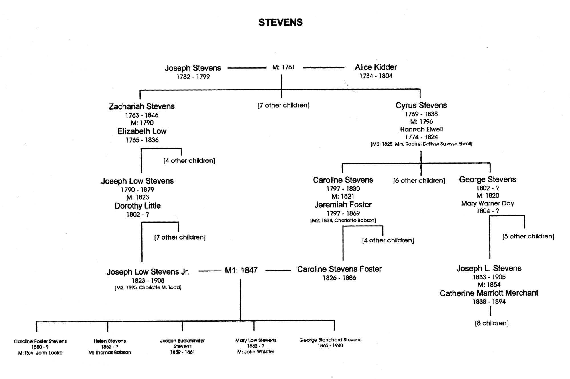
Appendix G: Family Trees, in Sarah Dunlap and Stephanie Buck, Fitz Henry Lane: Family and Friends (Gloucester, MA: Church & Mason Publishing; in association with the Cape Ann Historical Museum, 2007), 164–66.
Also filed under: Stevens, Caroline Foster » // Stevens, Joseph, Sr. and Dorothy Little »
Personal notebook
Wilson Museum, Castine, Maine
Note about historical importance of this Castine landmark: "On Saturday afternoon, August 11, 1855, with my friend the marine artist Fitz. H. Lane of Gloucester" visited Trask's Rock
Also filed under: Biographical information »
Essex County Probate Records, Volume 424, Leaves 34 & 35
The will disposed of Lane's property (including watch and diamond breast pin), his monetary assets, and gave to the city of Gloucester a painting of the Old Fort. Joseph Stevens, Jr. and T. Sewall Lancaster were named executors. It was signed by Lane on March 10, 1865.
Also filed under: Chronology » // Davidson, Dr. Herman Elvas » // Documents / Objects » // Funeral & Burial » // Galacar, Elizabeth » // Lancaster, T. Sewall » // Mellen, Mary Blood » // Page, Eben » // Stevens, Caroline Foster » // Wilbur, Horace B. »
Personal diary
Wilson Museum, Castine, Maine (A00060-1a-1h)
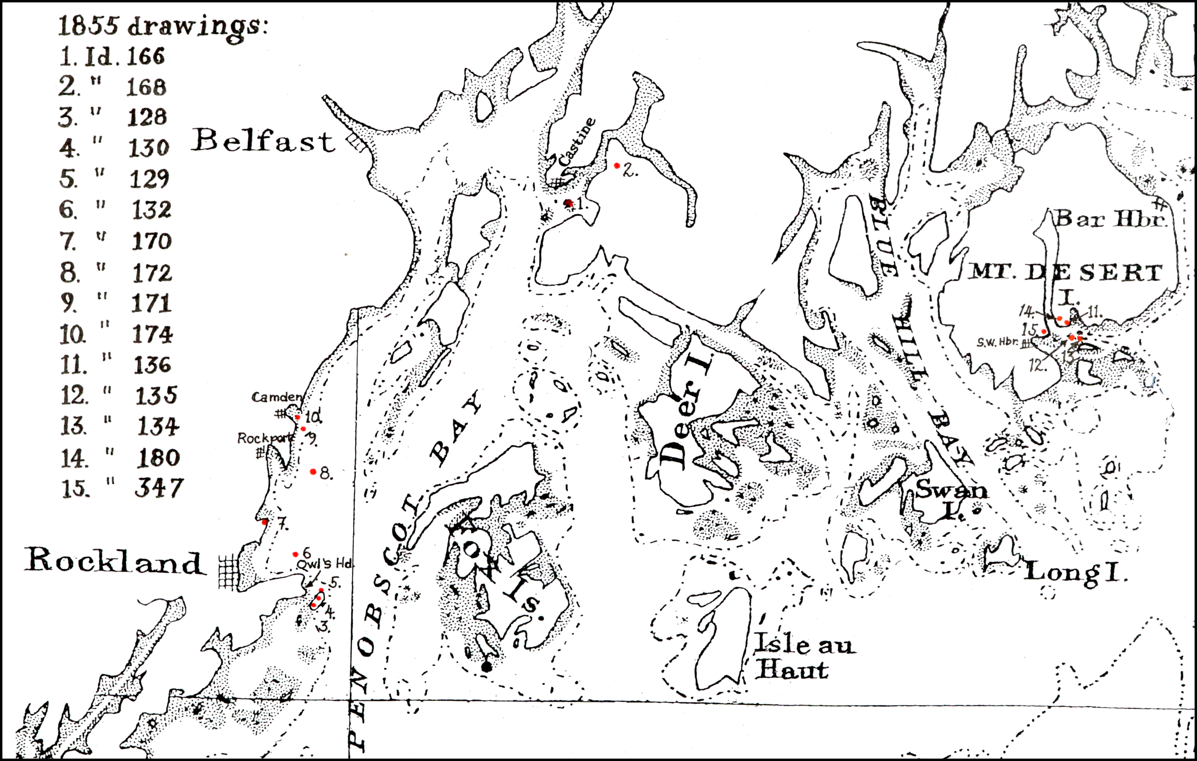
Description of an excursion taken by Joseph Stevens, Jr., Lane, Witherle, Samuel Adams, Jr., and George Tilden around the islands of Maine near Mt. Desert. The group hired the Sloop "Superior" which was owned by Pilot Getchell. In his diary, Witherle mentions multiple times that "Lane took a sketch" especially when the water was calm. Lane often stayed on board the boat, while the others went ashore.
Excerpts of the diary include:
August 16: "Lane has a knack for frying fish."
August 17: "leaving Lane to take a sketch, we took a climb."
August 19: "went to ascend one of the highest mountains. 3/4 the way up we had to wait – once in a while for Lane who with his crutches could not keep up with us – but got along faster than we thought possible . . .Lane got up about an hour after the rest of us."
The entire text is transcribed in an account published by the Wilson Museum.
View related Fitz Henry Lane catalog entries (6) »
Also filed under: "Superior" (Sloop) » // Adams, Samuel, Jr. » // Biographical information » // Blue Hill » // Castine » // Chronology » // Diaries / Ledgers / Etc. » // Mount Desert Island & Rock » // Somes Sound » // Tilden, George » // Witherle, William Howe »
Provenance (Information known to date; research ongoing.)
Marks & Labels
Marks: Inscribed upper left (in red ink): 39 [numbering system used by curator A. M. Brooks upon Samuel H. Mansfield's donation of the drawings to the Cape Ann Museum]
Related Work in the Catalog