loading 
Fitz Henry Lane
HISTORICAL ARCHIVE • CATALOGUE RAISONNÉ • EDUCATIONAL RESOURCE
An online project under the direction of the CAPE ANN MUSEUM
An online project under the direction of the CAPE ANN MUSEUM
Catalog entry
inv. 28
The Old Fort and Ten Pound Island, Gloucester
1850s Oil on board (study) 12 1/4 x 20 3/4 in. (31.1 x 52.7 cm) 16 1/2 x 24 1/2 in. (frame) No inscription found
|
Related Work in the Catalog
Supplementary Images
Provenance (Information known to date; research ongoing.)
Samuel H. Mansfield, Gloucester, Mass.
Cape Ann Museum, Gloucester, Mass.
Exhibition History
No known exhibitions.Published References
Wilmerding, John. Fitz Hugh Lane. New York: Praeger, 1971.
Ronnberg, Erik A.R., Jr. "Views of Fort Point: Fitz Hugh Lane's Images of a Gloucester Landmark." Cape Ann Historical Association Newsletter 26, no. 2–4 (April, July, September 2004)., fig. 2. ⇒ includes  text
text
Wilmerding, John. Fitz Henry Lane. Gloucester, MA: Cape Ann Historical Association, 2005. Reprint of Fitz Hugh Lane, by John Wilmerding. New York: Praeger, 1971. Includes new information regarding the artist's name., ill. 31.
Craig, James. Fitz H. Lane: An Artist's Voyage through Nineteenth-Century America. Charleston, SC: The History Press, 2006., pl. 19, text, p. 139.


Commentary
The Old Fort and Ten Pound Island, Gloucester is an apparent study for – or unfinished version of – the larger painting The Old Fort and Ten Pound Island, Gloucester, 1850s (inv. 30). It depicts all the major landforms, rocks, and buildings, blocked in using only their basic colors and dark and light values. The sky and water are painted as pure values of blue without any detail of waves or clouds.
This painting represents a fascinating illustration of Lane’s working methods: he essentially made a stage set, using features of the natural landscape and their color values. He then populated the set with all the vessels, people, water details, weather, clouds, and atmosphere to be seen in his finished works.
Lane's working methodology has been confirmed by infrared and X-ray scans of the underpainting and drawing beneath a number of his finished paintings. The scans show Lane drawing in the landforms and buildings in pencil or thin paint and scumbling in the darks and lights with a dilute brown tone to provide the major dark and light contrasts. Following this, he paints in the vessels and the details, including the elaborate sky and cloud formations over the top. This method follows the working logic of Lane's drawings in which he carefully outlines the topographical details of a scene with strict attention to the proportion and scale of all the elements, but without vessels, people, clouds or even color notes.
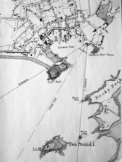
The Old Fort and Ten Pound Island, Gloucester shows how Fort Point looked prior to 1848, and may have been intended as a look back to a time before Gloucester Harbor’s development accelerated, beginning with the construction of Rogers's wharf: 1848–51. The view looks out from Duncan St. on Harbor Cove's northeast side. Fort Point’s summit is occupied by a nondescript wooden shed and the remains of Fort Defiance. At the foot of the point is the wharf of John W. Lowe – a cob wharf dating back to the early 18th century. On the right is the sandy causeway connecting Fort Point to downtown Gloucester.
The foreground offers a glance at the rocky shore of Duncan’s Point at high tide with no hint of the activity found there at low tide. Even this hint of shoreline was reduced in his painting derived from this scene (Inv. 30). In subsequent harbor scenes of the late 1840's using this viewpoint, Lane painted the foregrounds at low tide, capturing a world of human activity and watercraft hauled out on the shore, shifting the focus of attention to people and their work. 1847 seems to mark this shift of attention and composition to foreground activity on sandy beaches and rocky intertidal zones, bringing human presence closer to the viewer – and the artist closer to the community of his youth and his rediscovered hometown
The unanswered question about this work is whether it was a preparatory study for the larger painting The Old Fort and Ten Pound Island, Gloucester, 1850s (inv. 30) or a commissioned painting that Lane never completed. We have only a few possible oil "studies" by Lane. Conversely, we know that he often did multiple versions of a painting for different clients. This may have been one that, for unknown reasons, was left undone.
– Sam Holdsworth