An online project under the direction of the CAPE ANN MUSEUM
Catalog entry
inv. 223
Gloucester Outer Harbor from near the Cut
Graphite on paper (3 sheets) 9 x 34 in. (22.9 x 86.4 cm) Inscribed (in pencil): Gloucester Outer Harbor from near the Cut. / F.H. Lane del. 1864. / Picture painted from this sketch for Joseph S. Friend, Sacramento California. This was probably the last of Lane's sketches from nature.
|
Recto
Explore catalog entries by keywords view all keywords »
Historical Materials
Below is historical information related to the Lane work above. To see complete information on a subject on the Historical Materials page, click on the subject name (in bold and underlined).
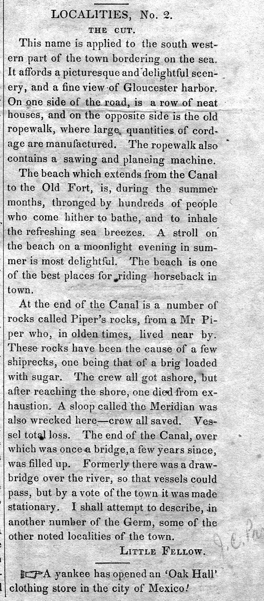
The Cut is the local name given to the canal that connects the outer Gloucester harbor to the navigable Annisquam River and thence on to the waters north of Cape Ann, so that vessels can in safety avoid circling the entire exposed eastern shoreline. It provided a vantage point for Lane's drawing Gloucester Beach from the Cut, 1850s (inv. 103) It was dug through the strip of beach separating the two bodies of water, first in the 1640s by the Reverend Richard Blynman, and is officially the Blynman Canal. This is purportedly the first canal dug in North America. For much of its history, however, the Cut has been filled in and the beach in its original state with a road laid over it, instead of cut through with a bridge over the canal (until 1950 and Route 128, the only vehicular access from the mainland to the Gloucester and Rockport peninsula). For a brief time around 1704 the canal was filled in by a storm but was soon dredged and re-opened. Then in 1723 it was again filled in by storms and did not get dug out until after 1822.
At this time, a consortium of Gloucester's leading men, most of them connected then and later with Lane, formed the company "Proprietors of the Gloucester Canal." They included Benjamin K. Hough, Jr.; James Mansfield; William Pearce, Jr.; John Mason; William Saville; Samuel Gilbert; and Winthrop Sargent. They managed to get the canal re-dug and a bridge in place, but the opening was too narrow to allow vessels of useful size to pass through. The bridge was also deemed unsafe. The company lost money and by 1843, the Cut was being refilled by the Town. During all the rest of Lane's life, the Cut as a canal did not exist. One could travel on a road, over sand, from the Pavilion, past the Ropewalk and the houses along the shore, to the western shores of the Harbor, Brookbank, Fresh Water Cove, and many other scenes and sites from which Lane painted. However, Lane and others continued to designate that section of their town as "The Cut."
After Lane's death, the quarrying interests on Wolf Hill (near the eastern end of the A. Piatt Andrew Bridge) were sufficiently motivated to reopen the canal in 1867.
– Sarah Dunlap (December, 2014)
44 x 34 in.
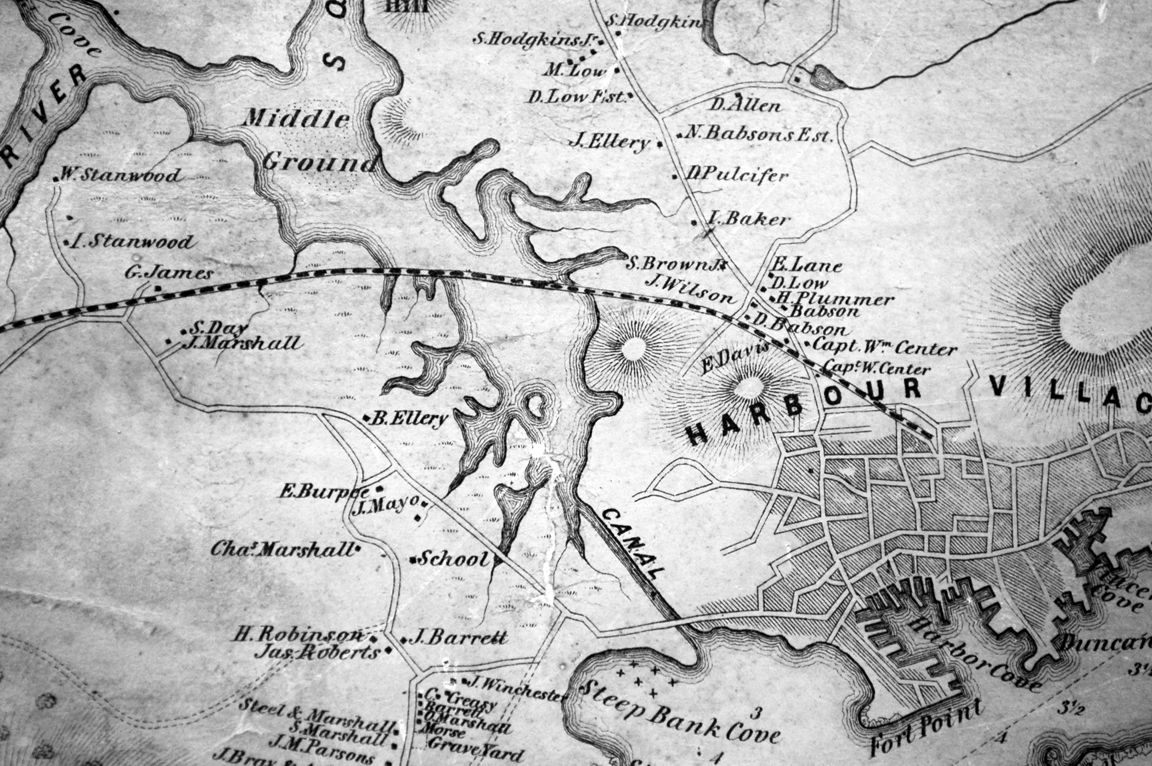
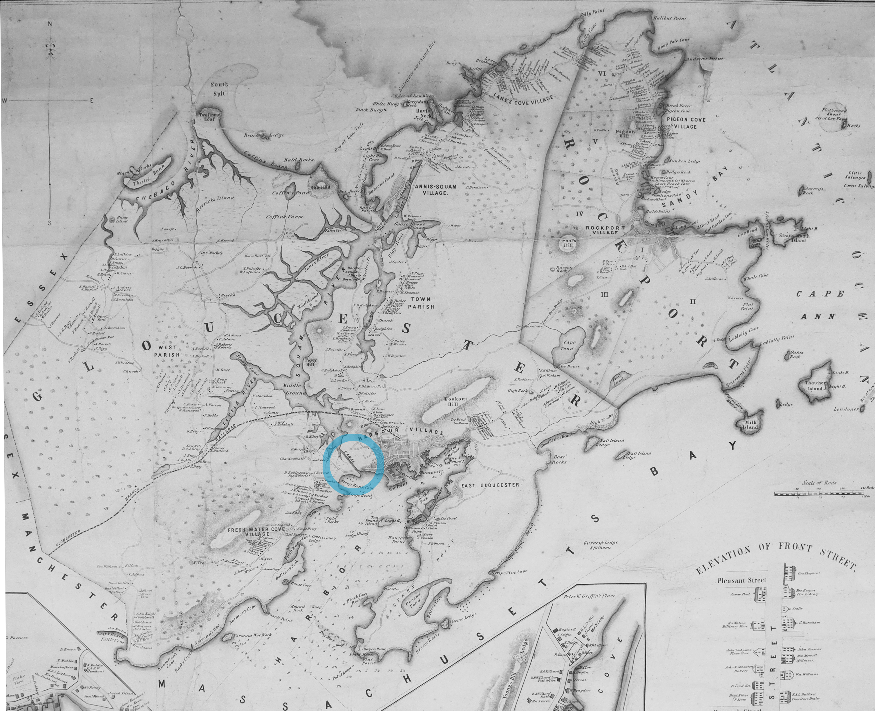
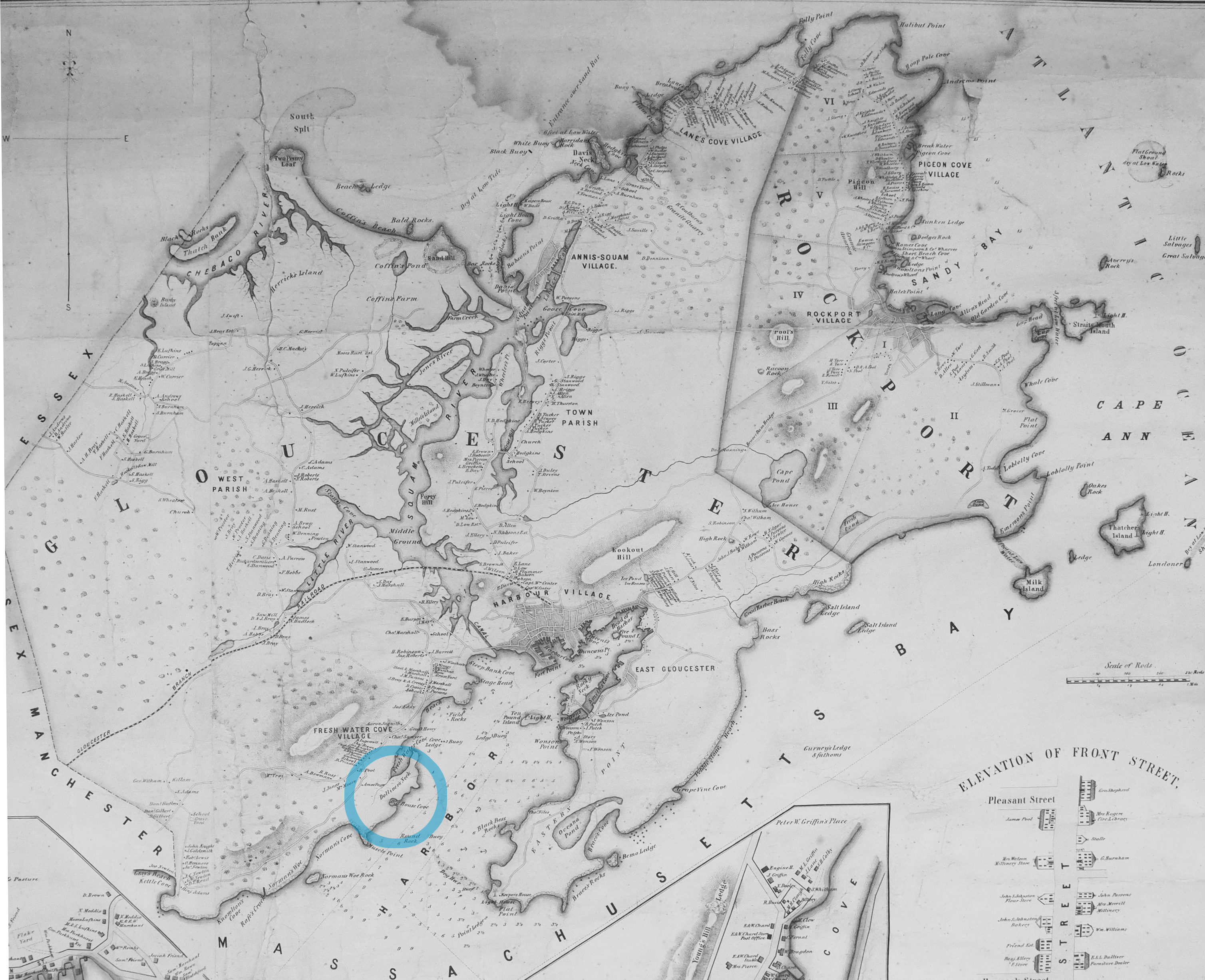
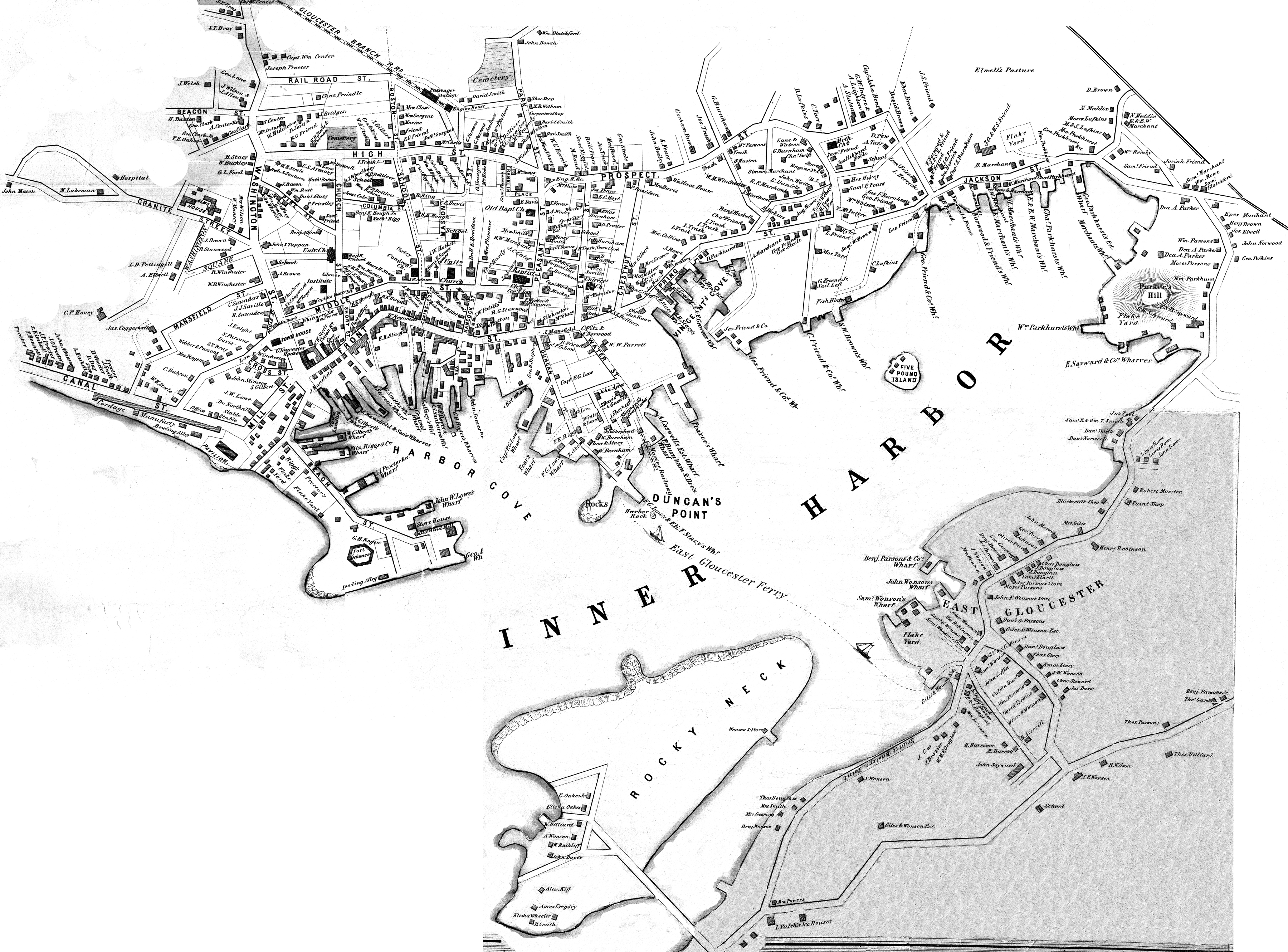
Henry Francis Walling, Map of the Towns of Gloucester and Rockport, Essex Co. Massachusetts. Philadelphia, A. Kollner, 1851
Cape Ann Museum Library & Archive
"Map of the Towns of Gloucester and Rockport, Massachusetts. H.F. Walling, Civil Engineer. John Hanson, Publisher. 1851. Population of Gloucester in 1850 7,805. Population of Rockport in 1850 3,213."
Also filed under: Babson House » // Town / Public Landings » // White-Ellery House »
Newsprint
D14-7
Cape Ann Museum Library & Archive
A short article entitled "The Cut," and signed "Little Fellow" describes the southwestern part of Gloucester and the beach between the Canal and the Old Fort.
Also filed under: Piper, John J. » // Ropewalk »
Personal journal
Wilson Museum, Castine, Maine
Box 2, F1 (A00772)
John Stevens was the younger brother of Joseph Stevens, and acquainted with Lane, spending time with him in Gloucester and at the family home in Castine. His journal, quoted below, includes reference to hunting plover and teal, school, sailing, local events. Mentions Castine mill, lighthouse, and block house.
"Friday [September] 17th: Cloudy all day. Wind N. blowing quite hard. A British Rig loaded with salt from Liverpool came into port last night. She run way up by the Monument and got aground. They kedged her off this P.M. and came down. She came in with one of these old English charts as her guide. They have the town set down on the Brooksville side, two miles + three quarters from the lighthouse."
"Wednesday [September] 22. . .Went down to the Indians Camp on the Back Cove. There were five camps of them."
Visits Gloucester from Castine:
"Wednesday [October] 27th. . .Left for Gloucester [from Boston] at 5 o'clock this P.M. arrived there safe + sound at 6 1/2 o'clock; went right down to the store and saw Joe. We then went up to his house and got supper.
"Thursday [October] 28th. At. Gloucester. Pleasant day. Went down to the "Cut" a gunning this morning before breakfast but saw no birds. Went out in the harbor this forenoon alone, had a fine sail but couldn't get a chance at any birds. Went out again this P.M. got down to East Point Light and the wind died all away, so I had to scull home."
"Friday 29th. Very pleasant day, went out in the harbor this morning with Joe. Took a walk this A.M. with "Lina", called on Mr. Lane + Doct. Hildreth. Joe + I went out in the harbor this P.M. I fired at some birds several times, but didn't get any. . . ."
Also filed under: Biographical information » // Bird Hunting » // Castine » // Castine – School » // Chronology » // Diaries / Ledgers / Etc. » // Stevens, Joseph, Jr. »
Newsprint
Gloucester Telegraph
"The Reef of Norman's Woe ... is now commemorated in painting too, one of the finest pictures from Lane's easel. ... The sketch was made at the pretty spot commonly called, we believe, Master Moore's Cove. Being some little way off the main track to Rafe's Chasm, it is seldom visited, except by the more inquisitive lovers of nature who leave the beaten road to pry out such pleasant places. ... We wish it might find a home buyer, rather than go off to enrich another community." Flowery description follows, then "There is another and larger work in the artist's studio, which, happily, is to be retained. It received much well deserved notice and commendation. The subject is a view southward from the 'Cut,' with the picturesque promontory commonly known as 'Stage Fort,' and historically interesting as the supposed spot of the 'Landing at Cape Ann' in the middle distance, and Eastern Point on the extreme left." More description follows, "Among other attractions of the studio, and particularly worthy of mention, is a cabinet picture with an effect similar to the Norman's Woe. The subject is chosen from the many sketches of the grand scenery of the Maine sea-coast with which the artist's portfolio is rich. It is a view of the Camden mountains sketches from the Graves, a jagged ledge far out in the bay, which is accessible in only the smoothest water."
Also filed under: Camden Mountains » // Newspaper / Journal Articles » // The Graves »
Lane did a remarkable series of paintings from Brookbank, the Sawyer homestead, which overlooks Fresh Water Cove. They show Dolliver’s Neck and how it protects the cove from the harbor. It is also visible in Dolliver's Neck and the Western Shore from Field Beach, 1857 (inv. 3), though somewhat disguised by the rest of the western shore in that view. He did a drawing and painting from Dolliver’s Neck looking west in Fresh Water Cove from Dolliver's Neck, Gloucester, Early 1850s (inv. 45).
Dolliver’s Neck is a small arm of land pointing north off the western shore of the Gloucester’s Outer Harbor. It is the cradling arm that creates Fresh Water Cove, a small cove where Samuel de Champlain found fresh water on his first visit to Gloucester Harbor in 1606. It was named for Samuel Dolliver who came from Marblehead in 1652 and bought a farm there.
In Lane’s time there were a few fishing shacks visible in some of his paintings where onshore fishermen could put their boats in from the pebble beach and salt marsh and be out in the center of the harbor without the long row or sail from the Inner Harbor. Fresh Water Cove itself is not deep enough at low tide for larger vessels to moor there so it has retained its small scale and intimate feel down through the years.
In 1900 a Coast Guard lifesaving station was built and manned on Dolliver’s Neck and many lives were saved along that rocky and treacherous coast between Gloucester and Magnolia.

Newsprint
From bound volume owned by publisher Francis Procter
Collection of Fred and Stephanie Buck
"We visited the studio of Mr. Fitz H. Lane a few days since, and were much pleased in examining some fine paintings from the pencil of this talented artist. Among the collection was a view of Long Beach, in this town, with which we were particularly interested.
The scene is taken immediately after a storm. The waves with their snowy crests are rolling in upon the beach, breaking against the sides of a vessel which has been driven ashore. In the background is seen the residence of Mr. Fessenden, and the surrounding scenery; on the right are visible the high headlands near the residence of Mr. Geo. Hovey, while stretching far away in the distance may be seen Fresh Water Cove, Dolliver's Neck, and the Old Pine Tree, the whole forming a beautiful picture and true to Nature.
Several other paintings were in process of completion, one a beautiful sunset scene, which was really beautiful to gaze upon; also a view of a gale at sea, with a gallant ship plunging madly through the waves, forming a striking contrast to the mild placid scene of the picture at its side.
Mr. Lane's paintings are true to nature, and in viewing them one can but admire the skill and genius of this talented artist, We advise all lovers of the art, who wish to spend an hour pleasantly, to visit the studio of Mr. Lane on Locust St. We can assure them that they will come away highly gratified, and have an earnest desire to call again." (1)
(1) See p. 2, column 3, Courtesy of the American Antiquarian Society
Also filed under: Chronology » // Fessenden, C. B. » // Fresh Water Cove » // Lone Pine » // Newspaper / Journal Articles » // Steepbank » // Studio Descriptions »

44 x 34 in.
Henry Francis Walling, Map of the Towns of Gloucester and Rockport, Essex Co. Massachusetts. Philadelphia, A. Kollner, 1851
Cape Ann Museum Library & Archive
"Map of the Towns of Gloucester and Rockport, Massachusetts. H.F. Walling, Civil Engineer. John Hanson, Publisher. 1851. Population of Gloucester in 1850: 7,805. Population of Rockport in 1850: 3,213."
Also filed under: Annisquam River » // Brookbank » // Fresh Water Cove » // Gloucester Harbor, Outer » // Maps » // Norman's Woe » // Stage Rocks / Stage Fort / Stage Head » // Steepbank » // West Gloucester – Little River » // Western Shore »

Engraving of 1819 survey taken from American Coast Pilot 14th edition
9 1/2 x 8 in.
Cape Ann Museum Library & Archive
D32 FF5
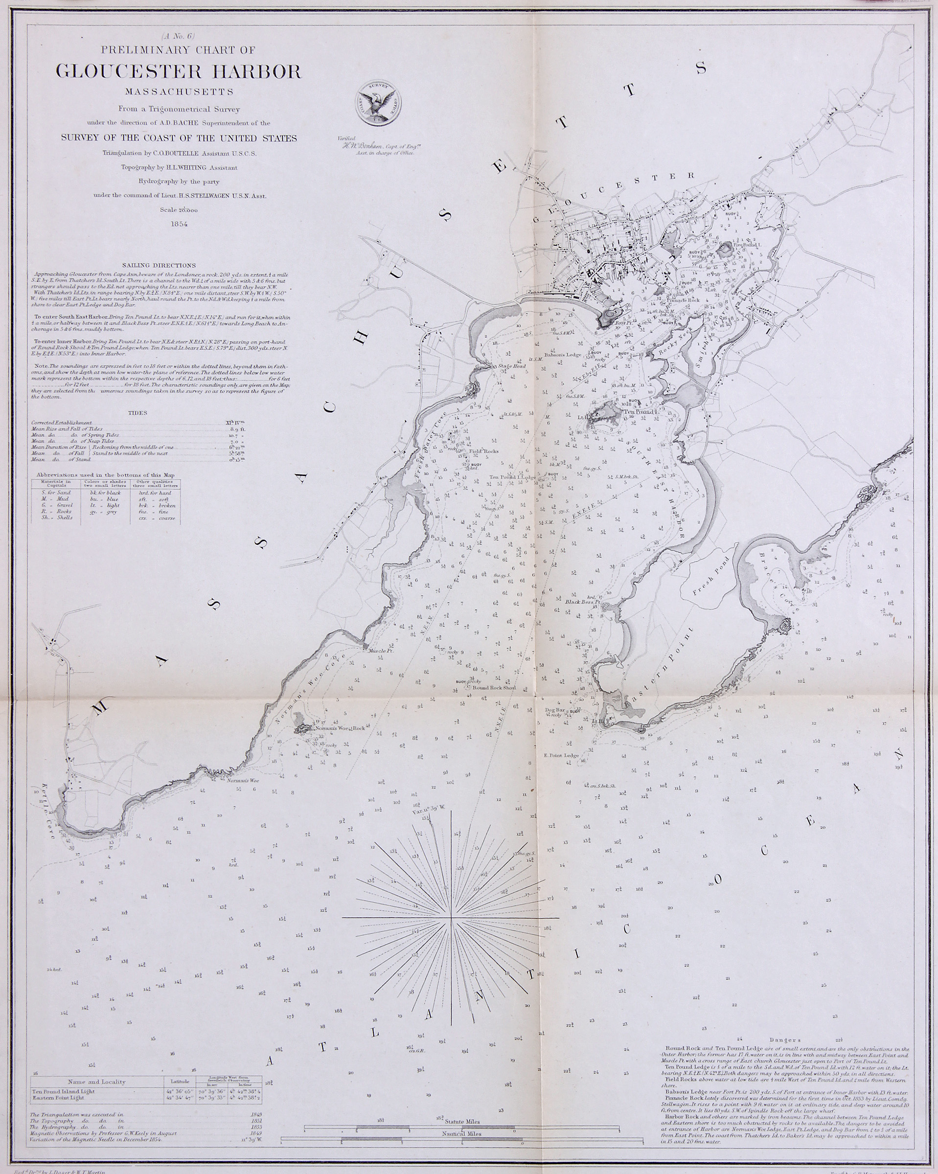
Also filed under: Eastern Point » // Maps » // Norman's Woe » // Ten Pound Island »
Newspaper
"Mr. Lane has just completed a third picture of the Western Shore of Gloucester Harbor, including the distance from 'Norman's Woe Rock' to 'Half Moon Beach.' It was painted for Mr. William E. Coffin of Boston, and will be on exhibition at the artist's rooms for only a few days; we advise all our readers who admire works of art, and would see one of the best pictures Mr. Lane has ever executed..."
"...solitary pine, so many years a familiar object and landmark to the fisherman."

Stereograph card
Cape Ann Museum Library & Archive
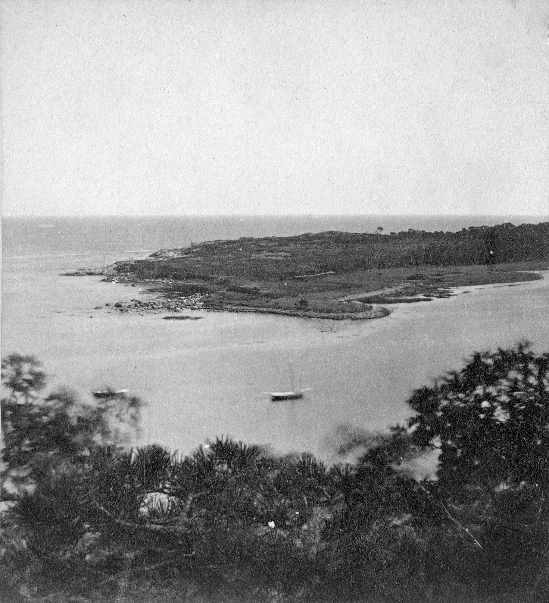
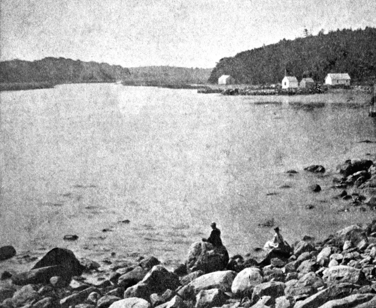
Taken from Steepbank, on the western side of Gloucester Harbor, and showing a small boat at anchor in the cove, then the Neck, and the sea beyond.
Also filed under: Fresh Water Cove » // Historic Photographs » // Lone Pine » // Steepbank »
Stereograph card
Cape Ann Museum Library & Archive
"Cape Ann Scenery, John S. E. Rogers, Low's Block. #54 Dolliver's Neck. Taken from Steepbank, on the western side of Gloucester Harbor, and showing a small boat at anchor in the cove, then the Neck and the sea beyond."
Also filed under: Historic Photographs »
4 x 5 in.
Cape Ann Museum Library & Archive
Freshwater Cove and Dolliver's Neck from the water off Stage Fort.
Also filed under: Fresh Water Cove »
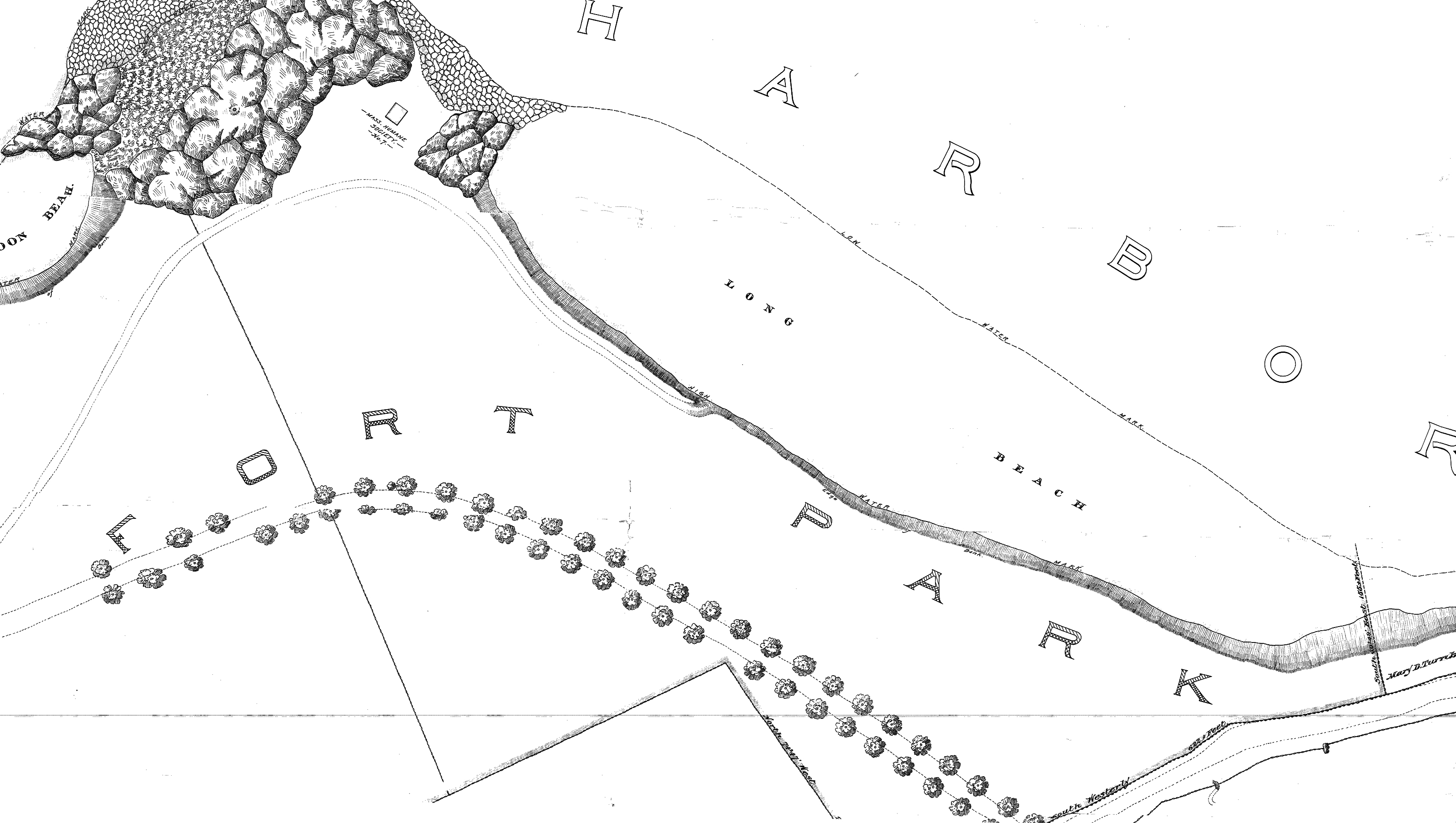
The beach between Stage Rocks and Tablet Rocks, adjacent to Fisherman's Field, was known during Lane's time as either Field Beach or Long Beach. It was a bit more rocky than Half Moon Beach. After Lane's time it became known as Crescent (or Cressy's) Beach. Field Rocks are just off the shore of the beach.
Cape Ann Museum Library & Archive
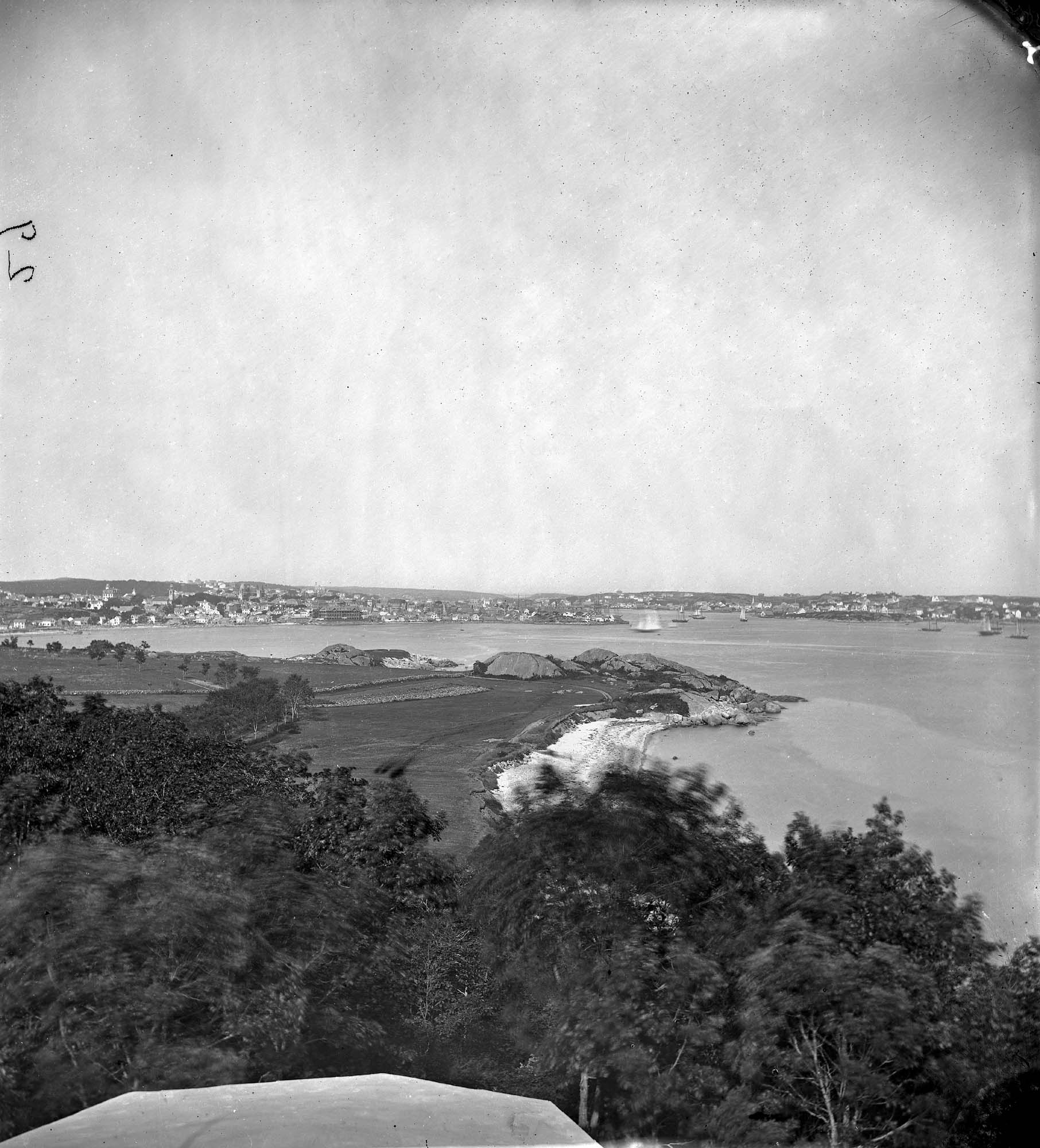
Stage Fort from Hough's Farm, showing a panorama of the harbor from Pavilion Beach to Fort Point and Rocky Neck.
Also filed under: Stage Rocks / Stage Fort / Stage Head »
Newspaper
"Mr. Lane has just completed a third picture of the Western Shore of Gloucester Harbor, including the distance from 'Norman's Woe Rock' to 'Half Moon Beach.' It was painted for Mr. William E. Coffin of Boston, and will be on exhibition at the artist's rooms for only a few days; we advise all our readers who admire works of art, and would see one of the best pictures Mr. Lane has ever executed..."
"...solitary pine, so many years a familiar object and landmark to the fisherman."
Also filed under: Coffin, William E. » // Dolliver's Neck » // Fresh Water Cove » // Half Moon Beach » // Lone Pine » // Newspaper / Journal Articles » // Norman's Woe » // Studio Descriptions »
Letter
Cape Ann Museum Library & Archive, Gloucester, Mass.
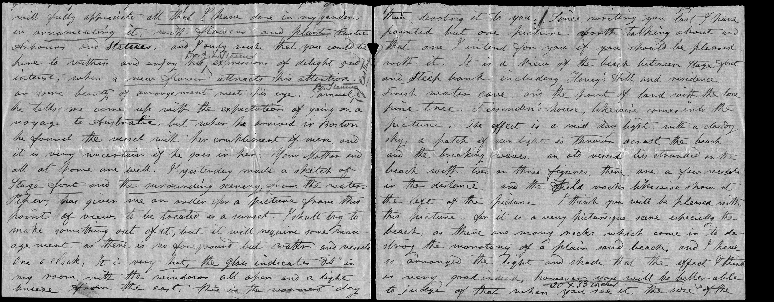
". . . will fully appreciate all that I have done in my garden, in ornamenting it, with flowers and plants, Rustic Arbours and Statues, and I only wish that you could be here to witness and enjoy his [Dr. J. L. Stevens] expressions of delight and interest, when a new flower attracts his attention, or some beauty of arrangement meets his eye. Samuel [B. Stevens of Castine] he tells me came up with the expectation of going on a voyage to Australia, but when he arrived in Boston he found the vessel with her compliment of men, and it is very uncertain if he goes in her. Your Mother and all at home are well. I yesterday made a sketch of Stage Fort and the surrounding scenery, from the water. Piper has given me an order for a picture from this point of view, to be treated as a sunset. I shall try to make something out of it, but it will require some management, as there is no foreground but water and vessels. One o’clock, it is very hot, the glass indicates 84° in my room, with the windows all open and a light breeze from the east, this is the warmest day . . .
. . . than devoting it to you. Since writing you last I have painted but one picture worth talking about and that one I intend for you if you should be pleased with it. It is a View of the beach between Stage Fort and Steep bank including Hovey’s Hill and residence, Fresh water cove and the point of land with the lone pine tree. Fessenden’s house, likewise comes into the picture. The effect is a mid day light with a cloudy sky, a patch of sunlight is thrown across the beach and the breaking waves, an old vessel lies stranded on the beach with two or three figures, there are a few vessels in the distance and the Field rocks likewise show at the left of the picture. I think you will be pleased with this picture, for it is a very picturesque scene especially the beach, as there are many rocks which come in to destroy the monotony of a plain sand beach, and I have so arranged the light and shade that the effect I think is very good indeed, however you will be better able to judge of that when you see it, the size is 20 x 33. . ."
Commonwealth of Massachusetts: Southern Essex District Registry of Deeds
1543 plan 0141_0001
The third of the three plans has the references on it “Plan showing the taking of land, flats and beach for Stage Fort Park…1898…”
Includes a reference to the home of Mary Turnbull which is Steepbank.
Also filed under: Maps » // Stage Rocks / Stage Fort / Stage Head » // Steepbank »
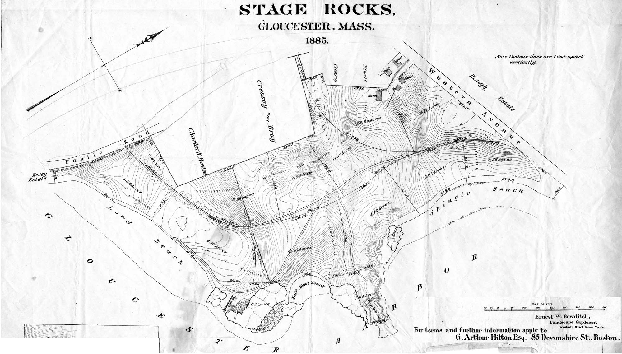
29 x 25 in.
Cape Ann Museum Library & Archive (#089)
Ernest Bowditch was a landscape gardener. This map shows some of the various names of landmarks around Stage Rocks.
Also filed under: Half Moon Beach » // Maps » // Stage Rocks / Stage Fort / Stage Head »
The owner of this flagpole has not been determined, but it is an interesting landmark in Lane's paintings. Often it appears in his drawings and not in his paintings, and Western Shore of Gloucester Outer Harbor, 1857 (inv. 107) contains the only image of a flag actually flying from the pole.
Fresh Water Cove is located on the west side of Gloucester’s Outer Harbor. It is protected from the harbor waters and the south-easterly seas by the arm of Dolliver’s Neck reaching north from the western shore. It’s a small, very still cove, only a few hundred yards from its mouth to the innermost shore.
The cove was visited by Samuel de Champlain in 1606. He was the first known European to enter Gloucester Harbor, which he named Le Beauport. He named Fresh Water Cove for the fresh water springs he found there, one a bit up from the shore, the other flowing below the high tide line and only accessible at half tide.
The cove, while very well protected from the weather, is small and very shallow at low tide and was never suitable for any large vessels, though there were fishing shacks along the shores edge and small boats were easily pulled up on the sand and salt marsh in its inner recesses. There was a wharf built in the early 1800s to service a granite quarry just up the hill from the cove, which could apparently handle larger vessels at high tide.
In Lane’s time, the most significant landmark from the cove was Brookbank, the Sawyer homestead where Samuel E. Sawyer was born in 1818. Sawyer made a fortune in Boston and returned to Brookbank every summer for fifty years. He became one of Gloucester’s first philanthropists. Lane did a series of paintings from the fields in front of Brookbank looking to the east from the house over Fresh Water Cove, the arm of Dolliver’s Neck and the harbor beyond. He also painted the opposite view in Fresh Water Cove from Dolliver's Neck, Gloucester, Early 1850s (inv. 45) looking west from Dolliver’s Neck over the cove to the Sawyer homestead and surrounding shoreline. Each of these paintings captures the perfect serenity of a high summer day in this secluded cove just off the busy harbor.
Stereograph card
Cape Ann Museum Library & Archive
Also filed under: Brookbank »
44 x 34 in.
Henry Francis Walling, Map of the Towns of Gloucester and Rockport, Essex Co. Massachusetts. Philadelphia, A. Kollner, 1851
Cape Ann Museum Library & Archive
"Map of the Towns of Gloucester and Rockport, Massachusetts. H.F. Walling, Civil Engineer. John Hanson, Publisher. 1851. Population of Gloucester in 1850: 7,805. Population of Rockport in 1850: 3,213."
Also filed under: Annisquam River » // Brookbank » // Dolliver's Neck » // Gloucester Harbor, Outer » // Maps » // Norman's Woe » // Stage Rocks / Stage Fort / Stage Head » // Steepbank » // West Gloucester – Little River » // Western Shore »
Stereograph card
Cape Ann Museum Library & Archive
Taken from Steepbank, on the western side of Gloucester Harbor, and showing a small boat at anchor in the cove, then the Neck, and the sea beyond.
Also filed under: Dolliver's Neck » // Historic Photographs » // Lone Pine » // Steepbank »
Newspaper
"Mr. Lane has just completed a third picture of the Western Shore of Gloucester Harbor, including the distance from 'Norman's Woe Rock' to 'Half Moon Beach.' It was painted for Mr. William E. Coffin of Boston, and will be on exhibition at the artist's rooms for only a few days; we advise all our readers who admire works of art, and would see one of the best pictures Mr. Lane has ever executed..."
"...solitary pine, so many years a familiar object and landmark to the fisherman."
Newsprint
From bound volume owned by publisher Francis Procter
Collection of Fred and Stephanie Buck
"We visited the studio of Mr. Fitz H. Lane a few days since, and were much pleased in examining some fine paintings from the pencil of this talented artist. Among the collection was a view of Long Beach, in this town, with which we were particularly interested.
The scene is taken immediately after a storm. The waves with their snowy crests are rolling in upon the beach, breaking against the sides of a vessel which has been driven ashore. In the background is seen the residence of Mr. Fessenden, and the surrounding scenery; on the right are visible the high headlands near the residence of Mr. Geo. Hovey, while stretching far away in the distance may be seen Fresh Water Cove, Dolliver's Neck, and the Old Pine Tree, the whole forming a beautiful picture and true to Nature.
Several other paintings were in process of completion, one a beautiful sunset scene, which was really beautiful to gaze upon; also a view of a gale at sea, with a gallant ship plunging madly through the waves, forming a striking contrast to the mild placid scene of the picture at its side.
Mr. Lane's paintings are true to nature, and in viewing them one can but admire the skill and genius of this talented artist, We advise all lovers of the art, who wish to spend an hour pleasantly, to visit the studio of Mr. Lane on Locust St. We can assure them that they will come away highly gratified, and have an earnest desire to call again." (1)
(1) See p. 2, column 3, Courtesy of the American Antiquarian Society
Also filed under: Chronology » // Dolliver's Neck » // Fessenden, C. B. » // Lone Pine » // Newspaper / Journal Articles » // Steepbank » // Studio Descriptions »

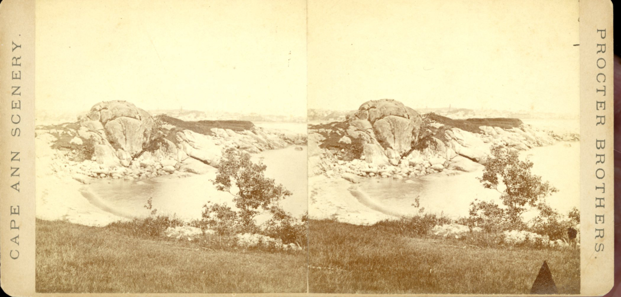
Stereograph card
Cape Ann Museum Library & Archive
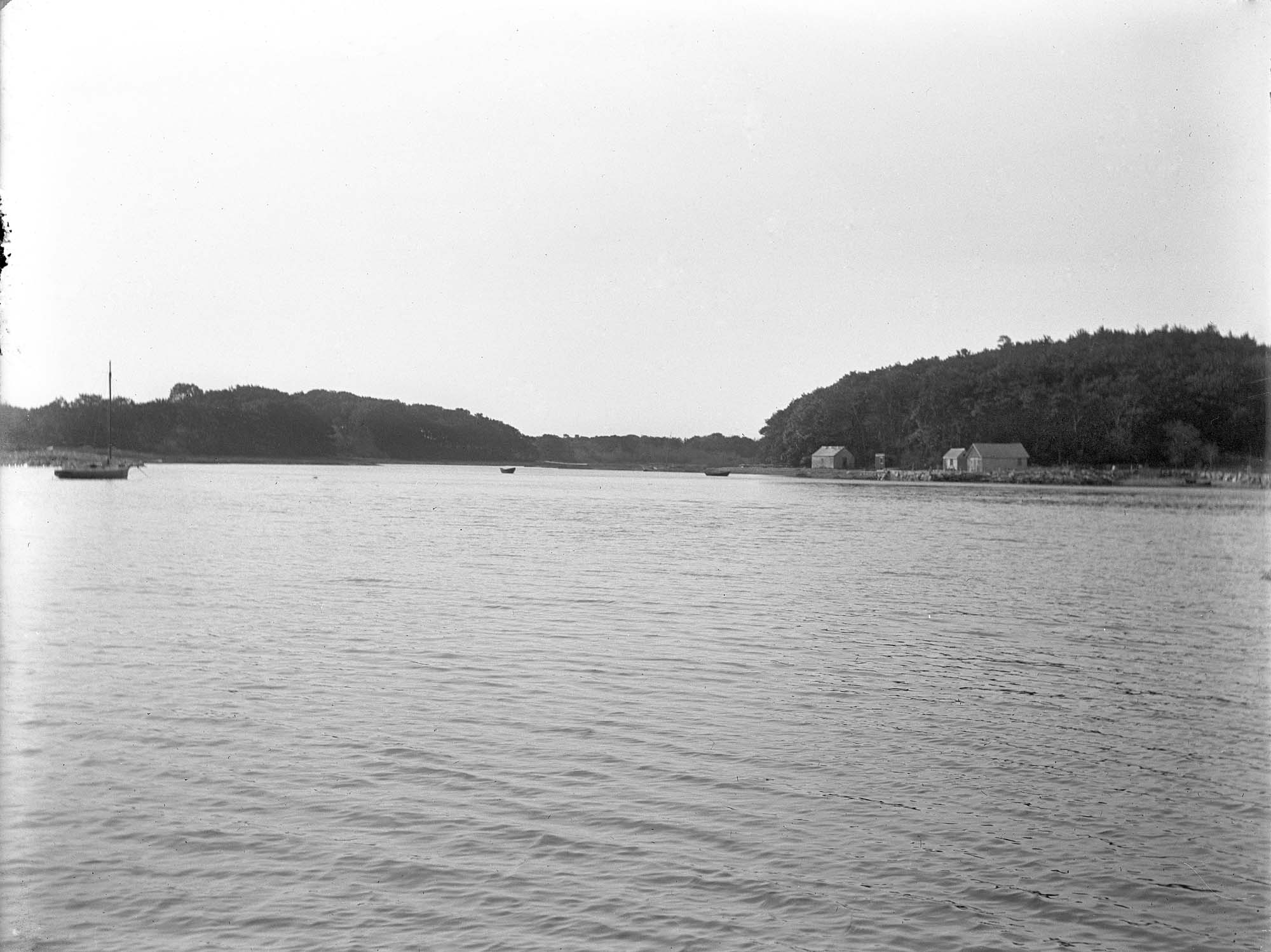
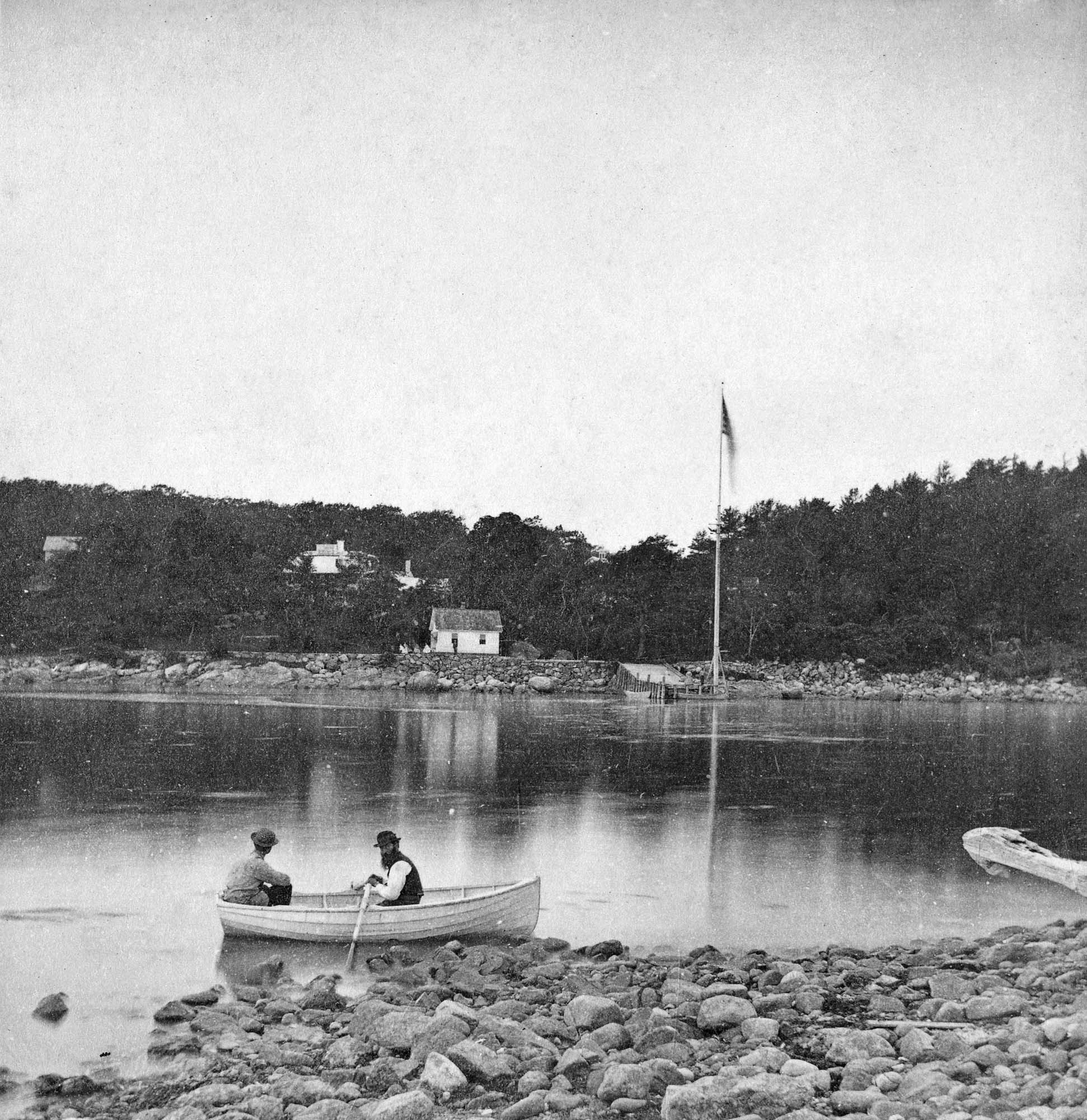
A view of a Cove on the western side of Gloucester Harbor, with the landing at Brookbank. Houses are seen in the woods back. A boat with two men is in the foreground.
Also filed under: American ensign / flag » // Brookbank » // Historic Photographs »
4 x 5 in.
Cape Ann Museum Library & Archive
Freshwater Cove and Dolliver's Neck from the water off Stage Fort.
Also filed under: Dolliver's Neck »

Although the exact location and information about the "Lone Pine" or "Old Pine Tree" is unknown, it was a well-recognized landmark in Lane's day. It was situated on the very tip of Dolliver's Neck, and as a result of its height and location near the shoreline, was seen easily from many points, especially across the water. The tree is clearly visible in Dolliver's Neck and the Western Shore from Field Beach, 1857 (inv. 3).
Newsprint
From bound volume owned by publisher Francis Procter
Collection of Fred and Stephanie Buck
"We visited the studio of Mr. Fitz H. Lane a few days since, and were much pleased in examining some fine paintings from the pencil of this talented artist. Among the collection was a view of Long Beach, in this town, with which we were particularly interested.
The scene is taken immediately after a storm. The waves with their snowy crests are rolling in upon the beach, breaking against the sides of a vessel which has been driven ashore. In the background is seen the residence of Mr. Fessenden, and the surrounding scenery; on the right are visible the high headlands near the residence of Mr. Geo. Hovey, while stretching far away in the distance may be seen Fresh Water Cove, Dolliver's Neck, and the Old Pine Tree, the whole forming a beautiful picture and true to Nature.
Several other paintings were in process of completion, one a beautiful sunset scene, which was really beautiful to gaze upon; also a view of a gale at sea, with a gallant ship plunging madly through the waves, forming a striking contrast to the mild placid scene of the picture at its side.
Mr. Lane's paintings are true to nature, and in viewing them one can but admire the skill and genius of this talented artist, We advise all lovers of the art, who wish to spend an hour pleasantly, to visit the studio of Mr. Lane on Locust St. We can assure them that they will come away highly gratified, and have an earnest desire to call again." (1)
(1) See p. 2, column 3, Courtesy of the American Antiquarian Society
Also filed under: Chronology » // Dolliver's Neck » // Fessenden, C. B. » // Fresh Water Cove » // Newspaper / Journal Articles » // Steepbank » // Studio Descriptions »
Newspaper
"Mr. Lane has just completed a third picture of the Western Shore of Gloucester Harbor, including the distance from 'Norman's Woe Rock' to 'Half Moon Beach.' It was painted for Mr. William E. Coffin of Boston, and will be on exhibition at the artist's rooms for only a few days; we advise all our readers who admire works of art, and would see one of the best pictures Mr. Lane has ever executed..."
"...solitary pine, so many years a familiar object and landmark to the fisherman."
Stereograph card
Cape Ann Museum Library & Archive
Taken from Steepbank, on the western side of Gloucester Harbor, and showing a small boat at anchor in the cove, then the Neck, and the sea beyond.
Also filed under: Dolliver's Neck » // Fresh Water Cove » // Historic Photographs » // Steepbank »
Letter
Cape Ann Museum Library & Archive, Gloucester, Mass.
". . . will fully appreciate all that I have done in my garden, in ornamenting it, with flowers and plants, Rustic Arbours and Statues, and I only wish that you could be here to witness and enjoy his [Dr. J. L. Stevens] expressions of delight and interest, when a new flower attracts his attention, or some beauty of arrangement meets his eye. Samuel [B. Stevens of Castine] he tells me came up with the expectation of going on a voyage to Australia, but when he arrived in Boston he found the vessel with her compliment of men, and it is very uncertain if he goes in her. Your Mother and all at home are well. I yesterday made a sketch of Stage Fort and the surrounding scenery, from the water. Piper has given me an order for a picture from this point of view, to be treated as a sunset. I shall try to make something out of it, but it will require some management, as there is no foreground but water and vessels. One o’clock, it is very hot, the glass indicates 84° in my room, with the windows all open and a light breeze from the east, this is the warmest day . . .
. . . than devoting it to you. Since writing you last I have painted but one picture worth talking about and that one I intend for you if you should be pleased with it. It is a View of the beach between Stage Fort and Steep bank including Hovey’s Hill and residence, Fresh water cove and the point of land with the lone pine tree. Fessenden’s house, likewise comes into the picture. The effect is a mid day light with a cloudy sky, a patch of sunlight is thrown across the beach and the breaking waves, an old vessel lies stranded on the beach with two or three figures, there are a few vessels in the distance and the Field rocks likewise show at the left of the picture. I think you will be pleased with this picture, for it is a very picturesque scene especially the beach, as there are many rocks which come in to destroy the monotony of a plain sand beach, and I have so arranged the light and shade that the effect I think is very good indeed, however you will be better able to judge of that when you see it, the size is 20 x 33. . ."
The Western Shore of Gloucester Harbor is characterized by the huge smooth glaciated boulders and granite outcroppings known as Stage Rocks, and the steep cliffs which separate Dolliver's Neck, Half Moon Beach, and Fresh Water Cove from the rolling fields beyond. The area was a quiet bucolic scene as portrayed by Lane in several paintings and drawings, in contrast to the bustling Inner Harbor. The shore is punctuated by the steep crags surrounding Rafe's Chasm and Norman's Woe at the southern end.
Stereograph card
Cape Ann Museum Library & Archive
Also filed under: Half Moon Beach » // Historic Photographs » // Stage Rocks / Stage Fort / Stage Head »

Colored lithograph
Cape Ann Museum Library and Archive
Also filed under: Stage Rocks / Stage Fort / Stage Head »
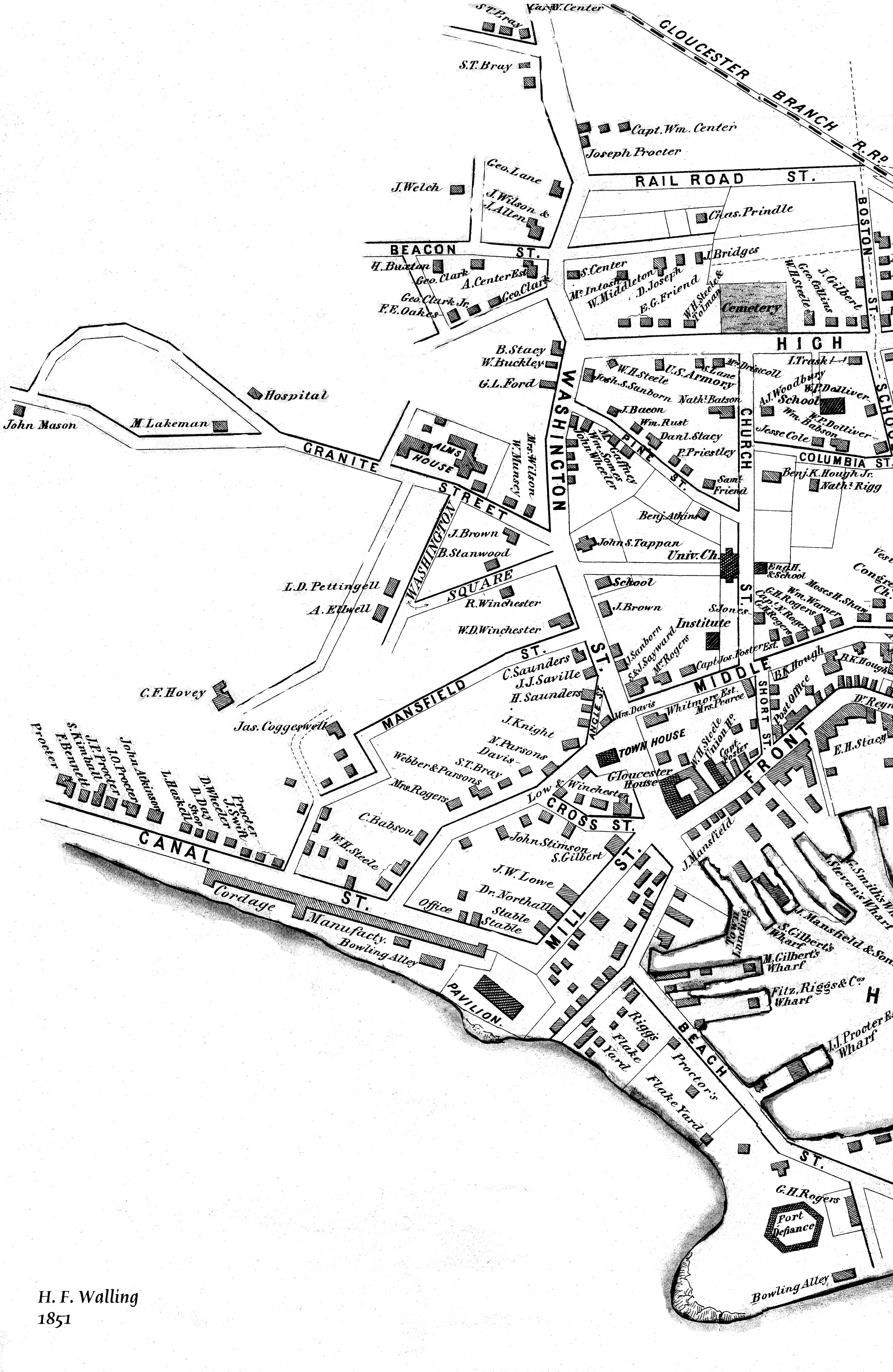
44 x 34 in.
Henry Francis Walling, Map of the Towns of Gloucester and Rockport, Essex Co. Massachusetts. Philadelphia, A. Kollner, 1851
Cape Ann Museum Library & Archive
"Map of the Towns of Gloucester and Rockport, Massachusetts. H.F. Walling, Civil Engineer. John Hanson, Publisher. 1851. Population of Gloucester in 1850: 7,805. Population of Rockport in 1850: 3,213."
Also filed under: Annisquam River » // Brookbank » // Dolliver's Neck » // Fresh Water Cove » // Gloucester Harbor, Outer » // Maps » // Norman's Woe » // Stage Rocks / Stage Fort / Stage Head » // Steepbank » // West Gloucester – Little River »
44 x 34 in.
Henry Francis Walling, Map of the Towns of Gloucester and Rockport, Essex Co. Massachusetts. Philadelphia, A. Kollner, 1851
Cape Ann Museum Library & Archive
"Map of the Towns of Gloucester and Rockport, Massachusetts. H.F. Walling, Civil Engineer. John Hanson, Printer. 1851. Population of Gloucester in 1850 7,805. Population of Rockport in 1850 3,213."
Also filed under: Baptist Church (Old, First, 1830) (Pleasant Street) » // Burnham Brothers Marine Railway » // Duncan's Point » // Five Pound Island » // Flake Yard » // Gloucester Harbor, Inner / Harbor Cove » // Harbor Methodist Church (Prospect Street) » // Low (Frederick G.) wharves » // Pavilion Hotel » // Procter Brothers » // Ropewalk » // Vincent's Cove »
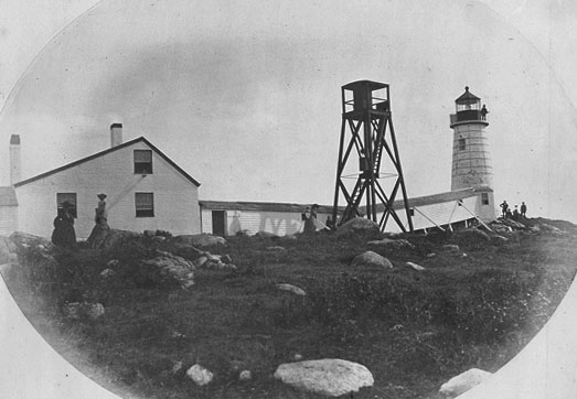
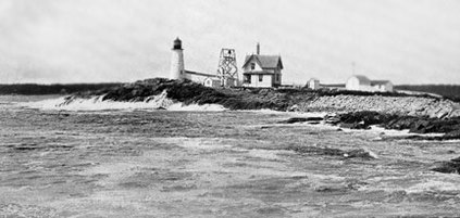
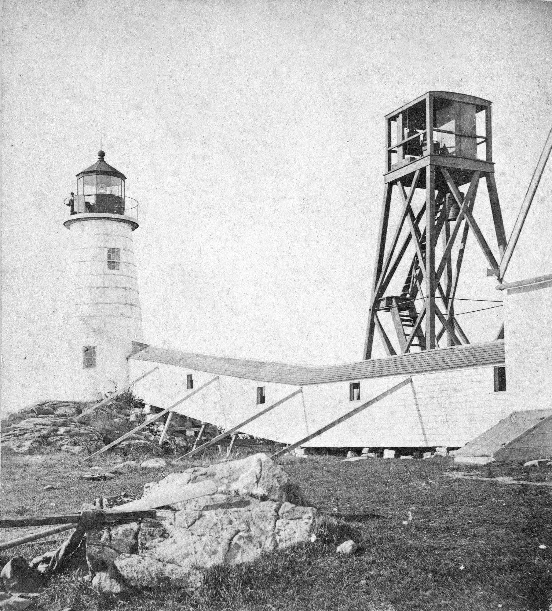
The Eastern Point Light is located in the town of Gloucester, Massachusetts on the east side of the entrance to Gloucester Harbor. In 1829, an unlit stone beacon was erected on Eastern Point to help mariners navigating Gloucester Harbor. Shortly thereafter, in 1832, a wrought-iron and copper lantern was added to the stone tower, and the first Eastern Point Light was born. During the 1840s, Gloucester became one of the most important fishing ports in America, and to cope with the increased fishing traffic, a new Eastern Point Light was built in 1848. The new 34 foot tower gained the nickname "The Ruby Light" due to its unique fixed red light. The Eastern Point Light was further improved upon in the following decades with the addition of a fourth-order Fresnel lens and fog bell.
This information has been shared with the Lane project by Jeremy D'Entremont. More information can be found at his website, www.newenglandlighthouses.net or in The Lighthouse Handbook New England. This information has also been summarized from Paul St. Germain's book, Lighthouses and Lifesaving Stations on Cape Ann.
U.S. Coastguard
http://www.uscg.mil/history/weblighthouses/easternpoint1832.JPG
For over 100 years the fishermen of Gloucester have been guided back to their home port by a lighthouse on Eastern Point. The present brick tower, painted a gleaming white, and standing on the long rocky point forming the eastern side of the harbor, was built in 1890, replacing on the same foundation the original tower built in 1832. Before 1832 a still older lighthouse, on Ten-Pound Island well inside of the harbor, had served as an entrance light, but this light was never visible until ships had actually found the entrance, hence the building of a lighthouse on the Eastern Point where it could be seen from far offshore.
Courtesy United States Coast Guard.
Also filed under: Historic Photographs »

Newspaper
"There are quite a number of visitors in town at the present time, who come to spend a few weeks by the seaside, during the sultry weather of August."
Also filed under: Fessenden, C. B. » // Newspaper / Journal Articles » // Procter Brothers – Gloucester, Mass. » // Tourist Industry »
Newspaper clipping
Cape Ann Advertiser
Collection of Fred and Stephanie Buck
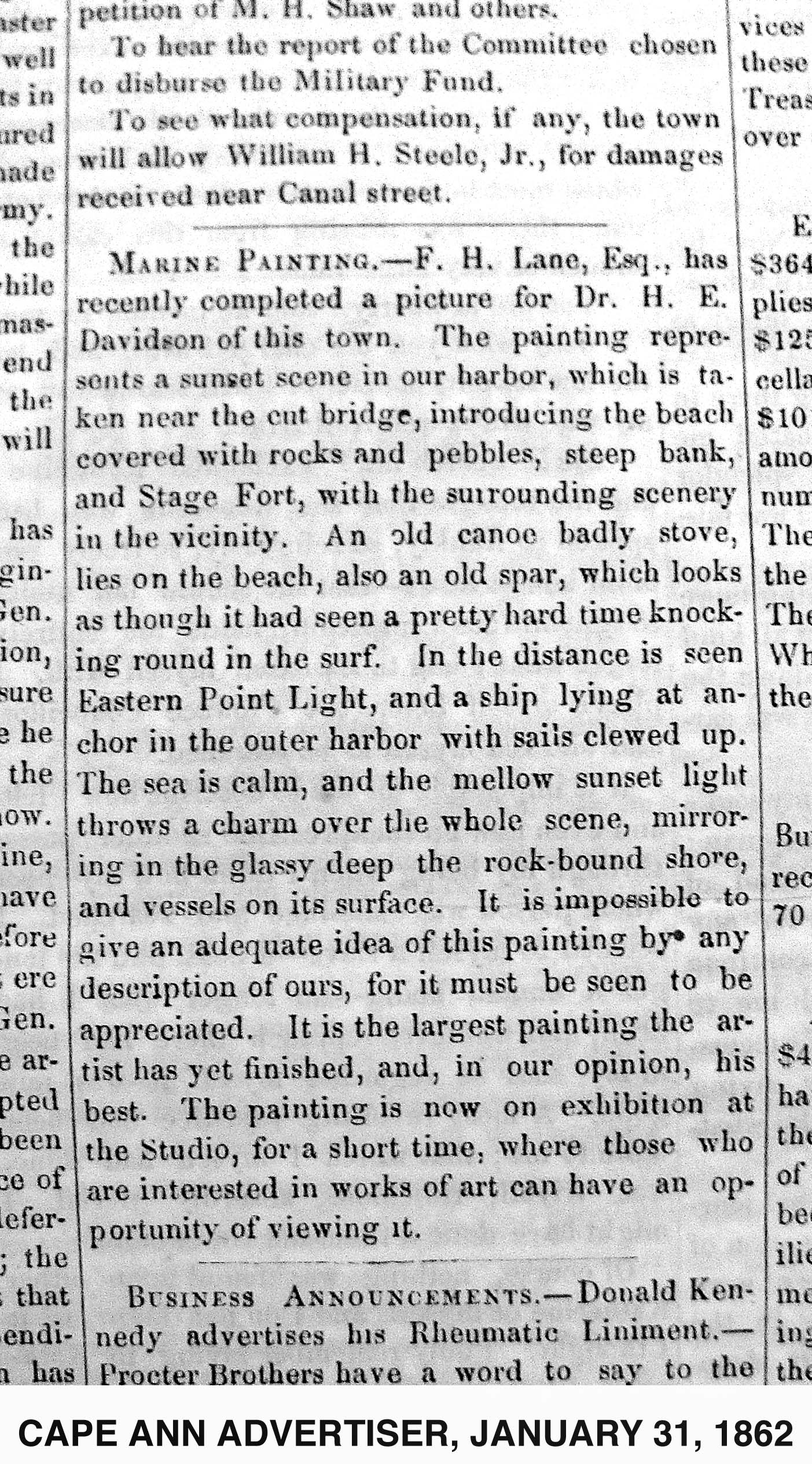
"MARINE PAINTING. – F. H. Lane, Esq., has recently completed a picture for Dr. H. E. Davidson of this town. The painting represents a sunset scene in our harbor, which is taken near the cut bridge, introducing the beach covered with rocks and pebbles, steep bank, and Stage Fort, with the surrounding scenery in the vicinity. . . It is impossible to give an adequate idea of this painting by any description of ours, for it must be seen to be appreciated. It is the largest painting the artist has yet finished, and, in our opinion, his best. The painting is now on exhibition at the Studio, for a short time, where those who are interested in works of art can have an opportunity of viewing it."
Also filed under: Davidson, Dr. Herman Elvas » // Newspaper / Journal Articles » // Studio Descriptions »
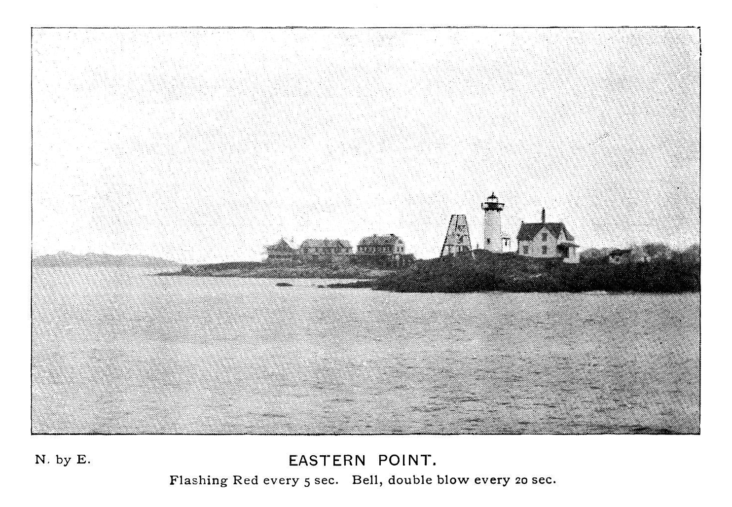
Plate from The Illustrated Coast Pilot with Sailing Directions: The Coast of New England from New York to Eastport, Maine including Bays and Harbors, published by N. L. Stebbins,1896.
Also filed under: Eastern Point »
Stereograph card
Published by Frank Rowell
Cape Ann Museum Library & Archive
Also filed under: Eastern Point »

Four circular glass prism lenses in a brass frame:
Lens diameters 19". Base 21" square x 19-1/2" high.
Cape Ann Museum. On permanent loan from the United States Coast Guard, 2013
When installed, the light source was fixed and the lens mount rotated.
Also filed under: Objects »
The Lane drawing with reference on it to Joseph S. Friend of Sacramento, California, appears to match the description of the Mellen-after-Lane painting of "Canal Beach, Stage Rocks and Norman’s Woe." This painting was loaned by Mrs. Edward Grover to an 1892 exhibit (noted as Mellen after Lane in the exhibit listing) along with "Old Fort and Ten Pound Island" (no artist listed).
The note on the drawing does not make reference to Mellen doing the painting, just that a painting was done from it for Joseph S. Friend of Sacramento. Whether Joseph Stevens—or whoever put the notations on the drawings—knew that other artists (e.g. Mellen) were using them to create finished paintings is unknown.
Joseph Sayward Friend was born in Gloucester, Massachusetts in 1824, the son of George Friend and Mary Ingersoll (Sayward) Friend, and brother of Augusta P. (Friend) Grover. In 1847 he married Helen Marie Elwell (1823–49), daughter of Elias and Thomasine Elwell. Helen died two years after her marriage to Friend.
Friend is listed in the 1850 census as being a “merchant” and still living in Gloucester. He moved to Calfornia around 1867, residing in Sacramento, and working as a “lumber merchant.”
Joseph Friend's sister Augusta Putnam Friend (1831–1903) married Edward Grover (c.1829–55) in Gloucester in 1854. They had two children: Edith and Edward. Edward (the husband) died on November 18, 1855 at age of twenty six, leaving Augusta a widow.
– Martha Oaks
44 x 34 in.
Henry Francis Walling, Map of the Towns of Gloucester and Rockport, Essex Co. Massachusetts. Philadelphia, A. Kollner, 1851
Cape Ann Museum Library & Archive
"Map of the Towns of Gloucester and Rockport, Massachusetts. H.F. Walling, Civil Engineer. John Hanson, Publisher. 1851. Population of Gloucester in 1850 7,805. Population of Rockport in 1850 3,213."
Related Work in the Catalog